Environmental Engineering Reference
In-Depth Information
time scales established at the outset were accom-
plished, a permanent monitoring was assured by
the project designer, so that the predicted solutions
could be quickly adjusted to real conditions.
it is noteworthy that, after the vegetation
removal from the surface of the cliff, which was
practically covered, it was possible to complete
the work design, particularly the definition of the
rockbolts location.
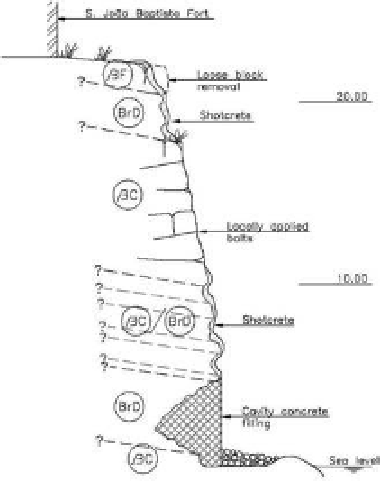
The headland is bordered by two cliffs, one to
the south, with about 45 m width and 10 to 15 m
height, and another to the east, with about 45 to
50 m length and 15 to 20 m height.
Both these cliffs have an approximately rectilin-
ear configuration though, on the east side, there is
also a small cove, possibly associated with an exist-
ing cave.
This cave has about 10 m width, a height between
1.5 and 4 m and a depth of about 6 to 8 m. Two
other caves have also been identified in the south-
ern cliff, although smaller in size and located above
the sea level.
There appeared to be a certain predominance
of breccious formations over basaltic formations.
The basalts are located essentially at the base level,
5.5
Cliffs below the Fort of Saint João Baptista
in Machico
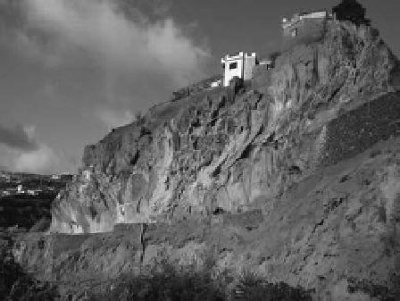
at the ne top of the Machico Bay coastline road,
there is a headland at the top of which the saint
João Baptista Fort was built.
a. General view of the cliff after the stabilization works
a. View of the southern cliff after the stabilization works
b. cross-section
b. Transverse section of the southern cliff
Figure 5.
cliff above the eR222 at sítio do calvário.
Figure 6.
cliffs underlying the saint João Baptista Fort.