Environmental Engineering Reference
In-Depth Information
Figure 5.
stabilization methods used on los Teques slope.
- Removal of loose stones and debris (450 m
2
).
- concrete buttress to support rock above cavities
(18 m
2
).
- 20 drain holes to reduce water pressure within
slope.
- Wire mesh hung on vertical face of slope
(260 m
2
).
- Reinforced cable net and rock bolts on unstable
rock blocks (180 m
2
).
- small fences (1 m high) to retain canalized debris
flows (2 fences of 15 m).
- cable belts around semi-unstable rock columns
(3 zones).
- Tensioned rock bolts in rock blocks (10 units).
The final cost of the stabilization works was
€45,000, less than a half of the budget cost of other
more extensive and general solutions.
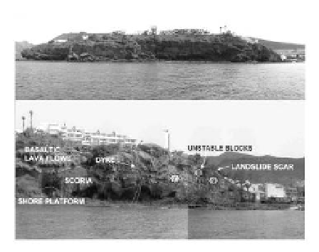
Figure 6. General view of Morro Jable cliff in
Fuerteventura island. Differentiation of geological mate-
rials on the slope.
2.2
Morro Jable cliff and footpath, Southern
Fuerteventura Is.
in 2006 a project for a coast footpath, 450 m long,
was done. it would connect Morro Jable harbour
and el Matorral beach, located in a main tourist
area at southern Fuerteventura island. The path
had to be designed on a narrow strip of land, along
a rocky cliff 30 m high, with a lot of caverns, land-
slide and rock-fall zones and very heterogeneous
about 40 percent of the footpath would be sup-
ported by the natural terrain and the remaining 60
percent by a metal structure of piles and girders.
a detailed geological and geotechnical study was
needed for an adequate development of the project,
because of the irregular morphology of the shore
and the geomechanical features of the cliff. in the
study there were included: (a) a geomorphologic
map of the shore, indicating cavern and slide zones,
rocky platforms, gravel and sand beaches; (b) a
geological section along the cliff with a description
of the volcanic layers and dykes; (c) the location
of unstable rocky wedges and blocks; (d) volume
measurement of caverns and caves at the base
of the slope; (e) proposal of protection methods
against the coastal erosion and stabilization tech-
niques for the unstable zones; and (f) evaluation of
the soil or rock bearing capacity for each of the
foundation points.
The geological study has been focussed on the
two parts of the zone: the tidal shore platform and
the rocky cliff.
The tidal shore platform is composed of basalt
rocks, corresponding to intrusive bodies and
tephra agglomerates, small patches of carbonate
beachrock and boulder and gravel beaches.