Environmental Engineering Reference
In-Depth Information
the cone theoretically, even though this cannot be
seen in the aerial photographs, since it is all covered
with recent lava flows. There have been observed
extensive open fractures (decimetric) cutting the
middle section of the D cone, with apparent nne
and nnW tectonic trend.
The geophysical profiles made on the east and
west flanks of the arenal volcano suggest a super-
ficial stratigraphy of 5 geophysical layers. The local
basement appears to be related to ancient volcanic
lateritic soils associated to the superior layer of the
aguacate group or to the Monteverde Formation:
lavas and pyroclastics of the Pliocene- lower-
Pleistocene (28). Using this information, we can
calculate the Poisson relation and the dynamic
elastic modulus and the shear modulus. in the case
of lava, this values are relatively low, considering
the high values of the primary seismic wave, which
implicates that the lavas are very good geomechan-
ically. For igneous rock, the value of the elasticity
modulus varies between 7 × 10
6
and 117 × 10
6
kPa,
being the usual value between 40 × 10
6
and
62 × 10
6
kPa, for a Poisson relation between 0.01
and 0.40, in general in the range 0.15-0.22 (20).
The hydrogeological studies are limited to the
geochemistry of the hot and cold springs (30).
These springs appear to be control by faults, recent
lava fields or the contact between the volcanic
massif and the ancient volcanic basement. We can
conclude, in general terms, that the phreatic sur-
face emerges in certain areas at 400 m.a.s.l in the
eastern flank, at 600 m.a.s.l in the northern flank,
at 500 m in the north-western side and at 550 m
in the western slope; in the south flank of the
arenal volcano, there are not any important
springs, since it is higher than the 600-700 meters,
because of its connection to the chato volcano
ladders. also, there are not any water sources at
altitudes greater than 650 m in the arenal cone,
except for insignificant drips or leaks and only
in the rainy season. everything shows that most
of the cone is in an unsaturated condition, due
to the high primary permeability in the lavas, as
well as the lack of impermeable levels inside the
cone's nucleus. Five gravity permeability tests were
made in a project called aportes Fortuna, in the
lavas from the chato volcano (similar to ones from
arenal), whose values vary between 3.6 × 10
-4
cm/s
and 7.3 × 10
-4
cm/s (34).
3
GeoTechnical MoDel
To be able to apply the analytical models through
formulations and computer software, it is necessary
to establish a simplified geological-geotechnical
model of the soils and rocks that constitute the
volcano and its foundation. The results of stud-
ies based on the mechanic of soils, once checked,
compared and selected, are shown in Table 2. if the
reader is interested in the lab results or any other
details, he can refer to the work of alvarado (2)
and alvarado et al. (5).
Based on all the geological-geotechnical infor-
mation, we raise a model of the rock massif from
the foundation and the edifice (
Fig. 3 a,b
). We
establish four layers or geotechnical levels (i to iV),
conveniently assuming for the analysis that they
behave as homogeneous materials, due to common
geological-geotechnical features that support the
previous simplification, even though there is a high
degree of heterogeneity between the layers.
The arenal cone (layer i) is analyzed as a frac-
tured rock mass, which at the same time can be
study in two different ways: a) stratified, very frac-
tured and drained, and b) as a mass, where the lavas
and lava auto-breccias are analyzed as a whole and
the pyroclastic rocks are subordinated. This was
the case of study selected by simplification, as the
macro behavior of the friction soils (c = 0, Φ ≠ 0).
Parallel to this, we have layer ii, composed mainly
by tuffs, as well as epiclastic deposits (transported
soils), all moderately compacted, healthy, and
3000 years old or younger. Usually drained and
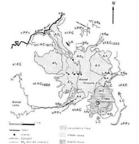
Figure 2. Geological map of arenal-chato volcanic
systema. uPPv, undivided Pliocen-Pleistocen volcanics;
lc, lower chato; ch; chatito (and la espina to north-
east); mc, middle chato lava field, uc, upper chato; la,
lower arenal; a4, a4 lava field; a3, a3 lava field; a2
1
, a2
low lava field; a2
h
, a2 high lava field; a1
l
, a1 low lava
field; a1
h
, a1 high lava field; utac, undivided tephra of
arenal and chato; utac
1235
, Quebrada Guilermina pyro-
clastic flow; utac
1968
, 1968 pyroclastic flows; utac
1975
,
1975 pyroclastic flow; sd, sedimentary deposits; sd
a
, allu-
vium; sd
m
, mud flow deposits; sd
t
, talus slope deposits.