Geology Reference
In-Depth Information
Time Scale (seconds)
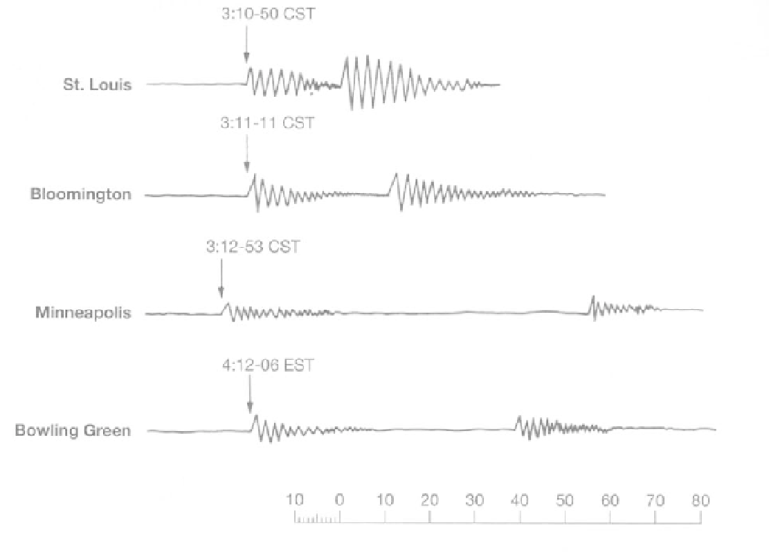
FIGURE 6.2
Partial seismograms for an earthquake. The P wave arrived at the St. Louis seismograph at 10 minutes and 50 seconds
after 3:00 P.M. CST. The second disturbance on the seismogram represents the arrival of the S waves.
4. a.
The epicenter of the earthquake can be pinpointed by
drawing compass arcs from three of the stations with radii
corresponding to the distances calculated in Question 3. The
intersection of these radii marks the epicenter. Do this in
Figure 6.3.
Mercalli Intensity Scale is commonly used to quantify
intensity descriptions. It ranges from I to XII (Table 6.1).
An
isoseismal
map shows the distribution of
seismic intensities associated with an earthquake.
The greatest impact of an earthquake is usually in the
epicentral region, with lower intensities occurring in
nearly concentric zones outward from this region.
The quality of construction and variation of geologic
conditions affect the distribution of intensity.
Seismic risk maps
have been based on the distribu-
tion and intensities of past earthquakes or on the prob-
ability of future earthquake occurrences (of a given
ground motion in a given time period). In this exercise
the first type of map is adequate for our examination of
seismic risk in middle North America; however, maps
based on the probabilistic approach may be needed in
other investigations. The latter maps do not express
intensity. Rather, they show probability of occurrence
of ground shaking that has a 10 percent probability of
being exceeded in 50 years.
Note that we also use the term
magnitude
to
describe an earthquake. The magnitude of an earthquake
is a measure of the amplitude of an earthquake wave on
a seismograph (Bolt, 1988). The Richter magnitude scale
is a commonly used standardized system of amplitude
measurement, and allows for comparison of different
b.
Where is the epicenter? (Give location within a state.)
c. Label it on the map (Figure 6.3).
d.
At what time did the earthquake occur? (Refer to
Figure 6.2.)
Intensity (6, Part A2)
The
intensity
of an earthquake at a site is based on the
observations of individuals during and after the earth-
quake. It represents the severity of the shaking, as per-
ceived by those who experienced it. It is also based on
observations of damage to structures, movement of fur-
niture, and changes in the Earth's surface as a result of
geologic processes during the earthquake. The Modified