Geology Reference
In-Depth Information
b. Site:
; Problems:
c.
Knowing that, to be classified as a sanitary landfill,
trash cannot be dumped into standing water, would this
site be a suitable place for an unlined sanitary landfill?
4.
If you were to excavate to a deeper level at the State Aggre-
gate pit, what additional geologic material could you obtain?
d.
List the problems that this site by the river would pre-
sent if it were selected as a modern sanitary landfill. Refer
to the guidelines given in the Introduction.
5.
Sanitary landfills must be covered daily (and after they are
closed) with a low permeability material to keep out precipi-
tation and runoff. (Otherwise, they do not meet the regula-
tions for sanitary landfills.)
a.
Which of the four (4) materials shown in the legend of
Figure 17.1 might be suitable for covering the waste
daily? Why?
PART B. PLANNING AND GEOLOGY
IN WACO, TEXAS
Waco, Texas, is situated in central Texas, between
Austin and Dallas, on the Bosque escarpment or fault-
line scarp and is underlain by eastward-dipping
bedrock of the Gulf Coastal Plain. The Upper Creta-
ceous formations outcropping in Waco include Taylor
Formation (Kta), Austin Chalk (Kau), South Bosque
Shale (Ksb), Lake Waco Formation (Klw), and Pepper
Shale (Kpe). Lower Cretaceous formations include Del
Rio Clay (Kdr) (which outcrops) and the Georgetown
Limestone and Edwards Limestone, which are in the
subsurface, outcropping to the west of the city. Tertiary
rocks outcrop to the East; Quaternary sediments occur
in the Bosque and Brazos rivers and terraces and in the
alluvium of these rivers. The cities of Austin, Dallas,
and San Antonio are also underlain by the same Upper
Cretaceous rock formations as found in Waco.
Surface bedrock formations in the Waco area affect
city growth because of their effect on topography, engi-
neering properties, soils, drainage, and construction;
subsurface formations may be important for water and
mineral resource extraction. The properties of these
geologic units are given in Table 17.3.
b. Trashmore's regolith has been deposited on bedrock by
glacial processes. Thus the unconsolidated material at the
surface might include outwash gravel, lake silt and clay,
clayey till, and wind-blown silt. What low permeability
material from the region might be suitable for landfill
cover?
6.
Which way is the bedrock dipping at Limey's Limestone
and what is the approximate angle of dip? (Hint: Use the
cross section and a protractor or use the symbols on the
map.)
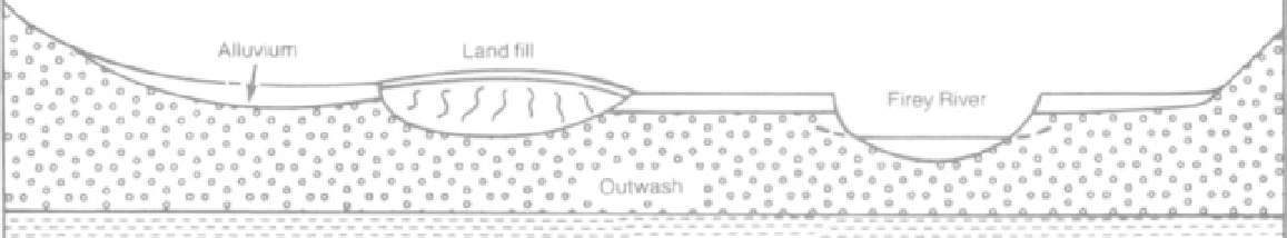
7. In Figure 17.2, a landfill is in an outwash valley on a flood
plain. Many such sites were selected in glaciated environ-
ments because a gravel pit was available.
a.
Complete the water table (dashed line) on both sides of
Firey River.
QUESTIONS 17, PART B
Use information in Figure 17.3 (Waco map at back of topic)
and Table 17.3, to answer the following questions.
1. a.
List the geologic symbols of formations or units
(Table 17.3) that might be used for extraction of sand and
gravel in the Waco area.
b. Place arrows to show the flow of groundwater in your
profile. (See Exercise 12 for assistance, if needed.)
Shale
FIGURE 17.2
Cross section through a landfill on an alluvial plain.