Geology Reference
In-Depth Information
Almyra?
Stuttgart?
2. Calculate the gradients that existed in 1915 and 1954 using
the flowlines that pass through Almyra.
a.
Gradient in 1915:
b.
Gradient in 1954:
3.
The hydraulic conductivity of the water-bearing deposits
averages 260 ft/day, and the effective porosity averages 17
percent. What was the groundwater velocity in the vicinity
of Almyra (refer to Exercise 12 for formula details;
v = KI/n
e
)
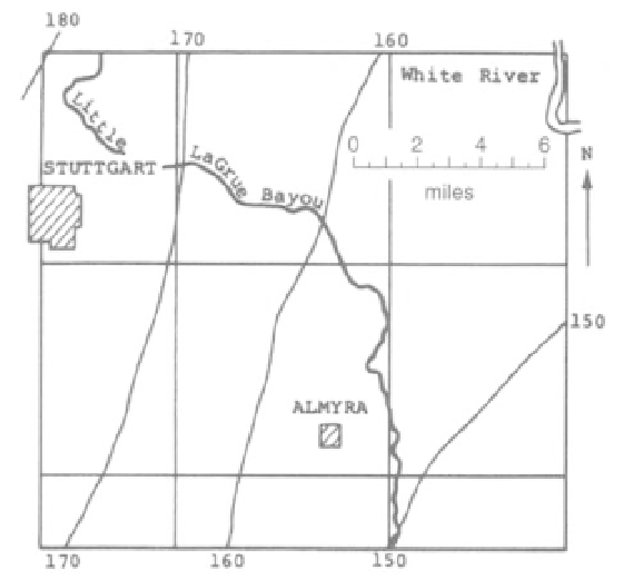
FIGURE 16.1
Altitude (in feet) of water level in Grand Prairie
region in 1915.
(Modified from Sniegocki, 1964)
a.
in 1915
Note: Subsequent studies of the Alluvial Aquifer
predict that it will become completely useless by 2015.
b.
in 1954
4.
Assume that the saturated sand in the northeastern part
of Figure 16.2 (along line A-A') is 40 feet thick. How much
groundwater, in ft
3
/day, flowed across A-A' during a sin-
gle day in March 1954? (Q =
KAI)
QUESTIONS 16, PART A
1.
a.
On Figure 16.2 construct a map that shows the con-
figuration of the water-level surface in March 1954, using
a contour interval of 10 feet. Compare this map with
Figure 16.1. What are the major differences?
5. Figure 16.3 indicates that there has been a significant low-
ering of water level. This means that more water is pumped
from the aquifer than is flowing into it. This negative change
in groundwater storage is termed overdraft. What could be
done to decrease the rate of decline, maintain the existing
level, or cause the water level to rise?
b.
On Figure 16.3 construct a map that shows the net
decline of water levels from 1915 to 1954. Use a contour
interval of 10 feet. What area has had the greatest
decrease in water levels?
c.
Starting at the east edge of Stuttgart, draw a flowline
across the 1915 map (Figure 16.1). Draw a similar flowline
passing through Almyra. What was the general direction
of groundwater movement in 1915 at
6.
"Ever think you'd run out of water where you live? Nei-
ther did the people in the Grand Prairie area of eastern
Arkansas. That's why this web site has been created so
you can understand what the Grand Prairie Area Demon-
stration Project (GPADP) is all about." At the Army Corps of
Engineers website you can see what the area's response was
to a study that predicted the loss of the upper Alluvial
Aquifer and the decline of the deeper Sparta Aquifer. It was
estimated that without the project, rice production would
drop to 23 percent of current value, partially replaced by less
productive dryland farming, and waterfowl recreation
income would decrease. The Sparta Aquifer is the source of
high-quality drinking water and, because it was being used
Almyra?
Stuttgart?
d.
On Figure 16.2 draw the flowlines passing through
Stuttgart and Almyra. What was the general direction of
groundwater movement in 1954 near