Geoscience Reference
In-Depth Information
Dabka Watershed
Non-monsoon Hydrological Hazards
(a) Decreasing Under Ground Water Level and Drying up Perennial Springs and Streams
During 1985-1990
During 2005-2010
Upper Lithology
2600
2600
Upper Lithology
Dry Aquifers
Perched Aquifers
Dry-up Springs
Perennial Springs
Perennial Springs
Dry-up Springs
2000
Lower Lithology
2000
Lower Lithology
Underground Water in
Lower Lithology
1400
1400
Underground Water in
Lower Lithology
0
1
2
3
Km.
0
1
2
3
Km.
(b) Perennial Springs and Streams: 1990
(c) Perennial Springs and Streams: 2010
Kunja
Kunja
Dhiriya
Dhiriya
Maniya
Maniya
Baunsi
Baunsi
Badhan
Badhan
Baghani
Baghani
Salwa
Salwa
Saur
Saur
Binayak
Gwalakhuti
Binayak
Gwalakhuti
Chhara
Chhara
Aniya
Aniya
Sigri
Sigri
Ghughu
Ghughu
Jalna
Jalna
Dau
Dau
Dhanaik
Dhanaik
Fathepur
Fathepur
Index
Springs
Streams
Index
Springs
Streams
Bagjala
Thrust
Faults
Bagjala
Thrust
Faults
Ranikoata
Ranikoata
Baluti
Baluti
(e) Decreasing Stream Frequency
(1990 & 2010)
(d) Decreasing Spring Density
(1990 & 2010)
Kunja
Kunja
Maniya
Maniya
Binayak
Binayak
Bausi
Bausi
Baghani
Baghani
Saur
Saur
Salba
Sigri
Sigri
Salba
Chhara
Chhara
Semalkhet
Ghughu
Semalkhet
Ghughu
Teet
Teet
Dola
Dola
Index
Jalana
Index
Jalana
Frequency (Streams/km )
2
Density (Springs/km )
2
Zones
Low
Moderate
High
V. High
Zones
Low
Moderate
High
V. High
Year 1990
Year 2010
Year 1990
Year 2010
Fathepur
Dhanik
Taliya
Fathepur
Dhanik
Taliya
Devipura
< 7
7-14
< 4
4-8
Devipura
< 6
6-12
< 4
4-8
Baluti
Baluti
Ranikota
Ranikota
14-21
> 21
8-12
> 12
12-18
>18
8-12
> 12
0
0.5
1
2
Km
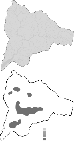
Figure 11.4.
Geo-hydrological impacts of climate change and land-use degradation during
1990-2010 in Himalaya, i.e., decreasing underground water level and dry up of perennial
springs and streams depicting by schematic diagram (a), decreasing perennial springs and
streams during 1990 and 2010 (respectively b and c), decreasing perennial springs density (d)
and decreasing perennial streams frequency (e).
1:25000
Accelerated land use degradation through climate change
As mentioned in the methodological section that the land use-informatics
module consists of comparative land-use land-cover mapping for year
1990 and 2010 to assess the changes and identifi ed the accelerating factors
for these changes as discussed in below. In order to monitor the dynamics


Search WWH ::

Custom Search