Geoscience Reference
In-Depth Information
hazards, i.e., fl ash fl ood, river-line fl ood, erosion, non-seismic land slide
in the monsoon period and drought hazard as drying up of natural water
springs and decreasing streams discharge in the non-monsoon period. An
attempt has been made in the present study to assess the trends of land-use
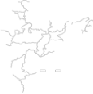
pattern in a fragile watershed located near a seismic and tectonically active
region of the Himalaya. The watershed lies between the latitude 29°24'09”-
29°30'19”E and longitude 79°17'53”-79°25'38”N in the North west of
Nainital Township (Fig. 11.1). The region encompasses a geographical area
of 69.06 km
2
between 700 m and 2623 m altitude above mean sea level. The
total population of the watershed is 9250 people, which includes 16 villages.
The population density is 76.02 person/km
2
. About 95% population of the
total population depends on agriculture and forest resources but the forest
cover is decreasing 0.36 km
2
per year and the agricultural production is also
decreasing due to climate change and drought hazard (Rawat 2013). The
Geographical Information System (GIS) and Remote Sensing (RS) techniques
have recently been widely applied to study land-use/land cover changes
Dabka Watershed
Location Map
Kunja Reserve
Forest Area
Maniya
D
I
A
I
N
4
Binayak
Reser
ve
F
orest A
rea
0
100
200
Baghani
Km
Bausi
3
Saur
Salwa
Sigri
Chhara
Semalkhet
Ghughukhan
Teet Reserve
Forest Area
1
Dola
Jalana
2
Index
Sites of 4 Sample Microwatershed
Dens Forest (Ghughu)
Open Forest/Scrubs (Jalana)
Agriculture Land (Bausi)
Barren Land (Maniya)
Fathepur
Ranikota
Dhanak
Taliya
Meteorological station
Hydrological station
Drainage
Village Boundary
1
Baluti
2
Devipura
3
0
1
2
0.5
Km
4
1:25000
Figure 11.1.
Location map showing selected sample micro-watersheds with 16 villages and
location of hydrological and meteorological stations installed in the study area.


Search WWH ::

Custom Search