Geoscience Reference
In-Depth Information
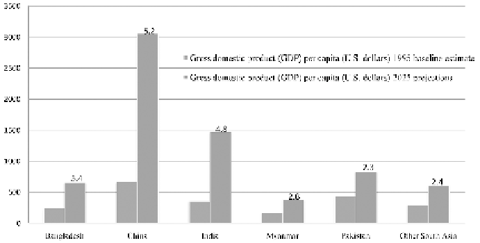
Figure 10.2.
Gross domestic product per capita in 1995 and projected for 2025 in HKH countries.
Numbers on the top of the bars graph is projected annual growth rate between 1995 and 2025
(Rosegrant et al. 2002).
demand is high in this region (Table 10.1), but per capita water availability
is very low—around 2,000 to 3,000 m
3
/capita/year—which is far less than
the world average of 8,549 m
3
/capita/year (UNEP 2008) and projected
declining water availability per capita. Moreover, total non-irrigated water
consumption increases in HKH (Table 10.2), 75% in the Yellow River basin
and by over 100% in the Indus and Ganges basins compared to 1995 levels
(Rosegrant et al. 2002). Arable land has declined from over 1 hectare per
person at the beginning of the 20th century to less than 0.1 ha at present
(GWP 2011). In this region of the world's fastest growing economies, water
is becoming an increasing security priority of the Himalayan countries to
sustain a growing economy, population growth and a bourgeoning of the
middle class. With increasing urbanization, almost 40% of the population
in the region now lives in the cities. As the result of a burgeoning middle
class, more than half of Asia's population will be living in urban area by
2025 (Fig. 10.3), and increasing energy consumption by 50% between 1996
and 2006 (UNEP 2008, IPCC 2007b).
Is climate change a challenge for the future sustainability of HKH?
The ecologically fragile Himalayan region is one of the most economically
underdeveloped and most densely populated mountain ecosystems on the
planet making the region highly vulnerable to the impact of climate change.
Climate change is projected to have negative effects and will impact the
Himalayan rivers in two distinct ways; i) rising temperature is likely to
affect the Himalayan glaciers then altering the basins hydrology, ii) global
Search WWH ::

Custom Search