Geography Reference
In-Depth Information
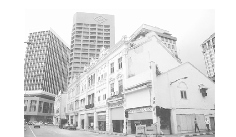
Figure 14-12
This photo shows the traditional Chinese/
European shop-houses that once dominated Kuala
Lumpur . These stand in sharp contrast to today' s
modern architecture.
Photograph courtesy of
B. A. Weightman.
Burma and Thailand each have long tails trailing
down the Malay Peninsula. Laos is landlocked, and what
eventually became Malaysia is fragmented between the
mainland and island realms.
Although colonials frequently turned internal hostil-
ities to advantage, no attempts were made to integrate
territorially-based ethnic identities into unified wholes.
In particular, Chinese and Indian migrants remained
largely unassimilated and resented. Indians were ex-
pelled from Myanmar (Burma) after independence.
Portuguese, British, and Dutch introduced changes
that shredded the fabric of indigenous societies; the net
result was the creation of social systems that could not
survive without the paternalism of colonial govern-
ments. France, Spain, and the United States also played
roles in the colonial period but their activities did not as
directly alter regional systems.
Cities were now founded on commerce and, with the
exception of Bangkok, were dominated by external
forces. Cities such as Jakarta, Manila, and Kuala Lumpur
were largely foreign places, alienated from the circum-
stances of the rural masses that made up 90 percent of
the population (Figure 14-12).
T Transportation (river, road, and rail) was immensely
improved to serve the colonial presence. Routes linked
raw materials with coastal ports, which served as entrepôts
for outgoing and incoming goods. This selective trans-
port development meant that many areas were devoid of
communication systems, isolated from the larger econ-
omy . Dual economies emerged, only to be exacerbated as
development increased. The rural-urban divide widened
as education and health care were made available to
urban elites. Only the Philippines had widespread
educational facilities.
POLITICAL PATTERNS
Politically , territorial units had little relevance to historical
and ethnic circumstances. T Territorial forms were derived
from European considerations: the need to access raw ma-
terials, the need to avoid conflict, and administrative con-
veniences. Boundaries did not coincide with settlement
patterns of ethnic groups that were often divided by bound-
ary constructs. One of the few instances where boundaries
were drawn according to ethnic differences is between parts
of Laos and Vietnam. Villages where the majority of houses
were built on piles with entrances facing east were assigned
to Laos. If the majority of houses were built on the ground
facing south, that village went to Vietnam.
Rising Nationalism
and Independence
Geographer Jonathan Rigg (1991) suggests, “The uneven
pattern of economic development, and the subordinate
position of the local populations, engendered a great deal
of bitterness. In addition, the paternalistic attitude of
many colonial administrators and their occasionally
harsh treatment of the local inhabitants created a reser-
voir of resentment that nationalist leaders were only too
happy to exploit in order to achieve their aims.”
Nationalistic leaders emerged because certain elites
had been given the opportunity to study abroad. These


Search WWH ::

Custom Search