Geography Reference
In-Depth Information
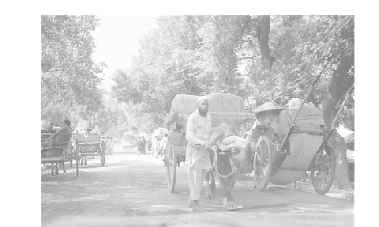
Figure 7-6
Here in Pakistan' s Northwest Frontier , water buf-
falo pull carts of tobacco to the market at Mardan.
The water buffalo are also suppliers of milk with a
high fat content.
Photograph courtesy of
B. A. Weightman.
Punjab
In 1947, Pakistan' s portion of the Punjab region (for-
merly India) held 60 percent of the population. It also
dominated the armed forces and produced more than
half of the GNP . Punjab long had been the breadbasket of
the subcontinent. Here flow the Indus, Jhelum, Chenab,
Sutlej, Beas, and other vital rivers. Out of the mountains
and foothills, streams and their
doabs
(lands between the
rivers) slope downward with masses of alluvium fanning
onto the Indus plain. Wheat, cotton, rice, oil seeds, and
sugar cane thrived under irrigation. This region has great
potential for development.
Hyderabad. The delta of the Indus merges with the mud
and salt flats of the Rann of Kutch.
Rann
means “salt
marsh” in Hindi. This 10,000 square mile (30,000 km
2
)
region between the Gulf of Kutch and the mouth of the
Indus, fills with water in the wet monsoon, when its
marshes attract thousands of flamingoes and other exotic
birds. In the dry season, it turns into a saline, clay desert.
Since the river distributaries have long been in flux, the
coast is dotted with dead ports. However, when Indus
flooding converges with high, ocean tides, the coast
floods inland for up to 20 miles (32 km). Mangrove and
tamarisk thickets fringe old and new beach-ridges and
bands of clay-like silts.
Sind epitomizes heat and aridity . Summer tempera-
tures can be well over 100
0
F (37.8
0
C) at midnight! It
rarely rains but when it does, it pours. Karachi, with an
annual average rainfall of about 8 inches, has recorded
12 inches (305 mm) of rain in 24 hours.
Second to Punjab in size and wealth, Sind has great
agricultural potential and in 1947 was in the process of
being colonized mainly by immigrants from Punjab.
However, much of rural Sind remains controlled by
za-
mindari
.. Originally ,
zamindars
collected taxes for the
Mughuls and later the Raj. Usually members of the elite,
they were or became large landowners, especially in Sind
and Punjab. They continue to control both land and
peasant farmers under a feudal system.
Zamindari
, be-
cause they are relatively rich and come from prominent
families, are often voted in as members of Pakistan' s Par-
liament. Many voters are coerced. Also, several
zamin-
dars
have their own prisons and armies. Polling stations
Sind
Sind, more than any other region, is wedded to the In-
dus. T To the north and west of Sukkur lie the Kirthar
Mountains. Alluvial fans permit cropping, but this west-
ern valley is underlain with clay and therefore subject to
water-logging and salinization—accumulation of salts.
Northward, the land turns to clay desert.
Centuries of seasonal flooding below Sukkur have
produced a
doab
between the Indus and the Nava Rivers.
Each part of this eastern valley at some time has been
traversed by an Indus stream. This fertile and productive
region has invited water control works through the cen-
turies. The
doab
, actually the ancient Indus delta, fades
eastward into the Thar Desert (Figure 7-7).
Further south, small but significant limestone out-
crops support the Sukkur water barrage and the city of


Search WWH ::

Custom Search