Agriculture Reference
In-Depth Information
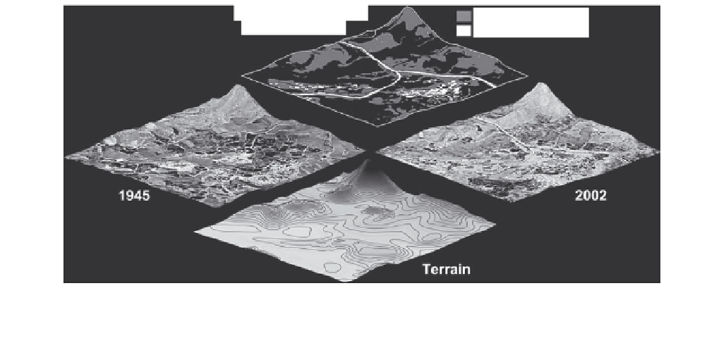
Changes in vegetation
and built structures
New woody vegetation
New structures
1945
2002
Terrain
FIGURE 22.3
GIS analysis of a 1 km
2
area in western Guangdong Province, China (Dianbai County) showing changes in the
agricultural landscape over time.
In the transition from a traditional to a more industrialized economy, built structures increased,
much agricultural land was abandoned, and woody vegetation — previously been burned and harvested for fuel — recovered in
formerly agricultural areas and in the hills. Images and data courtesy of Erle C. Ellis (www.ecotope.org for more information).
in many formerly agricultural lands, built structures
increased. As the images in Figure 22.3 indicate, multiple
layers of data that vary in content and time can be inte-
grated to understand the drivers and consequences of
changes such as these.
Knowledge of the farming practices that have been
used in the past in any particular landscape, combined
with knowledge of how different components of the land-
scape interact, makes it possible to understand how farm-
ing practices impact the nonfarm elements of a landscape,
and vice versa. Soil erosion rates, fertilizer inputs, pesti-
cide applications, irrigation, crop types and diversity, and
other practices and processes can be understood in terms
of landscape patterns. Based on this knowledge, recommen-
dations for change in either cropping patterns or farming
practices can be made, and decisions on agroecosystem
design can move beyond the farm and into the larger
landscape context.
many different stakeholders in an agricultural area (different
farmers, governmental agencies, conservation interests,
etc.). Its essence is the inclusion of natural ecosystems and
local biodiversity in management decisions and planning.
Thus, landscape-level management can be implemented by
an individual farmer who has direct control over only a small
part of the agricultural landscape of a region.
The implementation of landscape-level management
has two guiding principles:
1.
Diversify the agricultural landscape by increas-
ing the density, size, abundance, variety of non-
crop habitat patches, and by creating more
connections between them. These patches can
vary in their level of disturbance and “natural-
ness;” what they share in common is the ability
to be sites where natural ecological processes
can occur and where native or beneficial plant
and animal species can find suitable habitat.
2.
Manage cropping areas to reduce their negative
impacts on the natural environment and maxi-
mize their value as habitat for native species.
This means eliminating or reducing the use of
pesticides, inorganic fertilizer, and irrigation,
and finding alternatives to farming practices
that interfere with ecosystem processes, such as
frequent tilling, leaving fields without soil
cover for long periods, planting large-scale
monocultures, and mowing or spraying road-
sides and ditches.
MANAGEMENT AT THE LEVEL OF THE
LANDSCAPE
When agroecosystem management is carried out at the
level of the larger agricultural landscape, the antagonism
that so often exists between the interests of natural ecosys-
tems and those of managed production systems can be
replaced by a relationship of mutual benefit. Natural and
seminatural ecosystem patches included in the landscape
can become a resource for agroecosystems, and agroeco-
systems can begin to assume a positive rather than negative
role in preserving the integrity of natural ecosystems.
The concept of landscape-level management does
not necessarily mean coordinated management among the
The latter principle goes hand-in-hand with everything
discussed in this text up to this point. Reducing nonfarm


Search WWH ::

Custom Search