Biomedical Engineering Reference
In-Depth Information
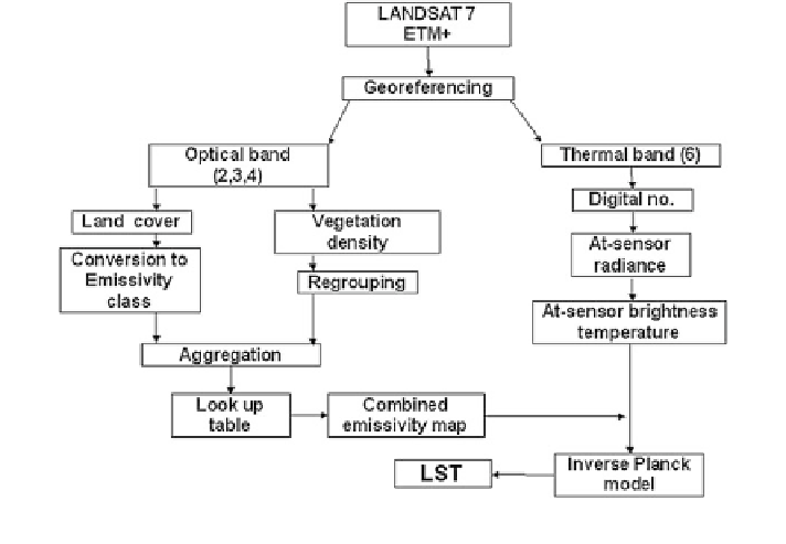
Fig. 2
Overall methodology for estimation of LST
land cover types, water body shows lowest surface temperature (Table
1
) in both
the seasons. The highest surface temperature was accounted for salt affected areas
in May and over barren land during August. The results indicate effect of strong
seasonal dependence on surface temperature under varying land cover types. The
overall sequence of temperature (Fig.
5
) under different land cover types from low
to high, is as follows.
May: Water, Aquatic vegetation, Crop land, Fallow, Steppe, Eroded land,
Built-up land, Barren, Sandy area, Salt affected area. Poor seperability is observed
between fallow and steppe land, barren and sandy area.
August: Water, Aquatic vegetation, Crop land, Built-up land, Fallow, Salt
affected area, Steppe land, Eroded land, Sandy area, Barren. Poor seperability was
observed between fallow and steppe land, eroded, barren and sandy area, salt
affected land and build-up land.
On the other hand, darker objects viz., barren land, rocks, etc., posses low
albedo values and hence absorbs maximum solar radiation and emits more long
wave thermal radiation during daytime and appears warmer. From the LST values,
it is evident that during May the land cover classes which could be clearly iden-
tified are water, aquatic vegetation, crop, eroded land, salt affected land, and built-
up land whereas during August only water, aquatic vegetation, and barren land
could be identified. The class intermixing in thermal region was evident among
built-up land, fallow, sandy area, and steppe land. The class intermixing of May
and August are given in Tables
2
and
3
, respectively.
Search WWH ::

Custom Search