Geology Reference
In-Depth Information
longer connected the water level fluctuated variously
among the now separated and smaller 8 lakes. Eventu-
ally only four retained any size. Others as Yonna and
Langell are now wide, flat valleys.
Pluvial Lake Chewaucan, whose remnants are
Summer Lake, Lake Abert, and the Chewaucan Marsh-
es, was almost 375 feet deep. The ancient lake, which
occupied an enclosed basin, was bounded on the west
by the Winter Rim fault and on the east by the Abert
fault scarp. Former lake levels are shown by prominent
beaches high above the present water line and by a
broad sand and gravel delta built when high lake waters
overflowed into the flat area just north of Paisley. The
moist habitat around Lake Chewaucan provided water
and vegetation for large herds of Ice Age bison, camels,
horses, and even elephants whose skeletal remains are
exposed along the old shorelines. Fossil bones of
waterfowl, fish, and freshwater mollusc shells also litter
the dry sands of the lake beds. The lakes today are fed
by small amounts of water issuing from several springs
and streams.
Two major events effected Lake Chewaucan.
The first, about 10,000 years ago, began when the
waters dried up to create the playa. The second occur-
rence during this warmer period was the catastrophic
eruption of Mt. Mazama on the present site of Crater
Lake about 6,900 years ago. Tremendous volumes of
pumice, ash, and volcanic dust created a dune field in
the northeast corner of Summer Lake and Lower
Chewaucan Marsh, 60 miles away from the volcanic
source.
Warner Valley and Alvord Desert occupy
similar depressions where small lakes persist. Bluejoint,
Campbell, Flagstaff, Anderson, Hart, and Crump lakes
are remnants of what was a large pluvial lake occupy-
ing Warner Valley, a basin that extends in a north-
south direction for 50 miles. Hart Mountain and Poker
Jim Ridge form the eastern boundary of the valley.
Alvord basin, bounded by a fault scarp along the base
of Steens Mountain to the west and a second fault to
the east, was once a lake 12 miles wide and 70 miles
long. The basin today contains the Alvord Desert and
a much reduced lake rimmed with a glistening white
alkali crust resulting when lake waters evaporate in the
summer leaving the residue.
Unfortunately during 1990 and 1991 an out-of-
doors "artist" used a rototiller and volcanic cinders to
mar the floor of Alvord Lake with a series of lines and
circles. Because the grafitti is on such a grand scale
that it can be seen from passing airplanes, the pristine
lakebed may take decades to heal itself.
Cooling during the Pleistocene also signalled
the outset of glaciation on Steens Mountain, the only
region in the Basin and Range to support large ice
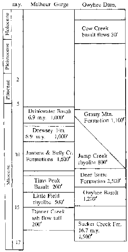
Great Basin Tertiary stratigraphy (after Walker,
1979)
483 square miles in Lake County, and Alvord Lake in
Harney County extended for 491 square miles.
Ancient pluvial Lake Modoc, which once
reached nearly 75 miles in length, has receeded to the
Upper and Lower Klamath lakes and Tule Lake in
California. With a climate change to dryer conditions
at the end of the Pleistocene 11,000 years ago, Lake
Modoc began to decrease in size. The lowering of
water was uniform at first, but once the basins were no