Geology Reference
In-Depth Information
Within these terranes the oldest rocks in the state are
to be found.
Although major events have been sketched out,
details of the geologic history are still only poorly
known. Geologists are now aware of the exotic nature
of most of the older rocks here, which have been
mapped and described as well as dated with fossils and
radioactive decay techniques. What remains is to
determine where each of the blocks or terranes origi-
nated as well as how and when they were transported
and accreted to North America.
Metamorphism, intrusion, and volcanic activity
annealed these exotic blocks to North America where
they became the foundation of northeast Oregon.
These remnants of the earth's crust in the Blue Moun-
tains offer an opportunity to study in detail a "collision
boundary", the point where multiple large-scale blocks
or tectonic plates have collided and merged with each
other. Here a natural outdoor laboratory is available to
view the wreckage of ancient islands that were cast up
on Oregon's prehistoric shores.
Following the accretion of the major exotic
terranes here, a vast shallow seaway of late Mesozoic
or Cretaceous age covered most of the state depositing
thousands of feet of mud, silt, and sand. This oceanic
environment of warm quiet embayments and submarine
fans was populated by ammonites and other molluscs
as well as by marine reptiles, while tropical forests of
giant tree ferns grew along the shore.
With uplift and gentle folding of the crust, the
shoreline, which ran northward through central Ore-
gon, retreated westward beyond the present day Cas-
cades, and a long interval of volcanism ensued. Thick
lavas intermittently oozed from fissues and vents
throughout the region during the Eocene and Oligo-
cene. Volcanic activity was interspersed with periods of
sedimentation and erosion when local basins or depres-
sions in the lava were filled with sediments deposited
there by streams. Reptiles, mammals, fish and plants
living in the tropical climate of this time died and were
buried in the volcanic sediments. Originating from
fissures in the Blue Mountains flow after flow of
Miocene lavas eventually covered almost a quarter of
the state. Areas of central and northeast Oregon were
a wasteland of dark basalt up to a mile thick. As the
lavas cooled and shrank, long vertical columns formed
within the layers. Today the harder basalts cap and
preserve many of the colorful rock displays.
Widespread glaciation in the Wallowas during
the Pleistocene gave the region its final unique appear-
ance. Beginning about 2 million years ago, the climate
rapidly grew colder with the advance of a continental
ice sheet southward as far as northern Washington,
Montana, and Idaho. Although the Wallowas weren't
entirely covered by ice, glaciers built up in valleys
formerly occupied by streams. At the height of the Ice
Ages, nine major glaciers spread through the moun-
tains, only to melt and retreat with warmer tempera-
tures.
Geology
Only in the past two decades has it become
apparent that the Blue Mountains province is actually
a number of smaller pieces of terranes which originated
in an ocean environment to the west. The word,
terrane, implies a suite of transported similar rocks
that are separated from adjacent rocks by faults. Seas
covered all of Oregon as far back as Triassic time, 200
million years ago, when these exotic blocks or terranes,
traversing the Pacific Ocean basin, began to collide
with the North American West Coast. As each of these
island blocks arrived, they successively docked against
the ancient North American craton, producing layered
bands of exotic terranes. The craton itself represents
the North American core or foundation of rocks native
to this continent.
Scattered along the North American West
Coast, these terranes are much more complex than
previously thought. New evidence suggests that after
collision movement of terranes by faulting was predom-
inantly southward up to late Triassic time, then north-
ward during the early and middle Jurassic, southward
in the late Jurassic and early Cretaceous, and then
finally northward from the late Cretaceous onward.
With such a complexity of movements, it is little
wonder that West Coast rocks look like a well-shuffled
deck of cards.
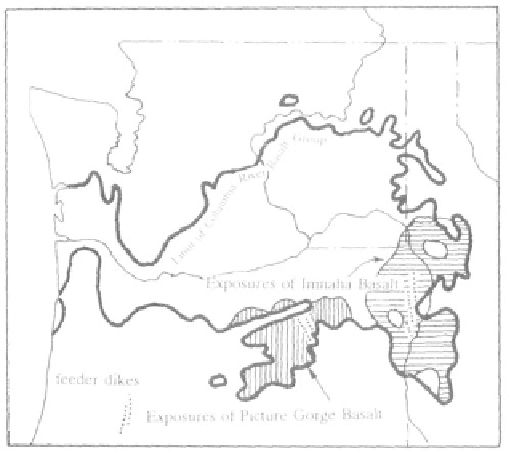
Distribution of Miocene Columbia River Group lava
flows in the Blue Mountains (after Anderson, et al.,
1987)