Geology Reference
In-Depth Information
Coastal Bays and Lakes
A steadily rising sea level as the result of
melting glacial ice has produced coves and bays that
line the shore. Alluviation by vigorous coastal streams
has kept pace with the sea level rise along the Oregon
coast south of Bandon so that the tide does not extend
far inland. From Bandon northward, however, drown-
ing has produced bays and marshes, and the saltwater
tide reaches as much as 20 to 30 miles upstream. Many
of the broad fertile plains and natural levees along
Oregon's coastal streams may be attributed directly to
alluviation during postglacial drowning. Were it not for
this, the coast might have narrow valleys less hospitable
to habitation.
Where the mouths of streams have not been
filled in with sediments, bays have formed. Varying in
size from larger inlets at Coos Bay and Tillamook to
smaller scenic coves at Depoe and Boiler bays, few are
very deep, and at low tide most display great areas of
mud flats interlaced by channels. Because of runoff and
sedimentation, a number of the bays must be constantly
dredged to allow passage of ships, and only the major
bays are used as sea ports.
One of the youngest and perhaps more ephem-
eral features of the Oregon Coast is the chain of
freshwater lakes within the sand dunes that occur in a
50 mile strip from Floras Lake at Cape Blanco to Lily
Lake near Heceta Head. Blocked by sand dunes
occupying low spots or former river valleys, the lakes
are fed by streams draining the western Coast Range.
At 3,164 acres, Siltcoos Lake south of Florence in
Lane County is similar in size to nearby Woahink,
Tahkenitch, and Tenmile lakes, making them among
Oregon's largest dunal lakes. The smaller string of
lakes north of Florence, Nott, Mussel, Alder, Dune,
and Buck, each less than 10 acres, are all comparatively
deep at 25 to 35 feet. Clear Lake south of Reedsport
in Douglas County and the similarly named Clear Lake
north of Florence are the two deepest lakes on the
coast at 119 feet and 80 feet. Dunal lakes vary in
elevation as well. The surface of Siltcoos Lake is 5 feet
above sea level, while that of Woahink is 38 feet.
Despite their diversity in size, the dunal lakes
all share an exceedingly fragile environment because of
the freshwater saturated sands beneath the lakes and
the nearby mixing of saltwater and freshwater to the
west. Around the lakes, the poor consolidation of
sands, which project 60 to 70 feet above the water
surface, makes them particularly susceptible to pollu-
tion, silting, and mudflows. All terrain vehicles, logging
clearcuts, and rampant development for lakeside homes
have already deleteriously affected most of these lakes.
The steep walls and narrow valleys of the
Coast Range in conjunction with the high rate of
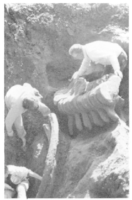
A Pleistocene fossil whale is being excavated near
Port Orford in Curry County (photo courtesy Ore-
gon Dept. Geology and Mineral Industries).
The precise chronology of terrace deposits
along the Oregon coast is still incomplete. Terrace
development is not a case of a simple steplike uplift of
the coast with stationary stages during which the
terraces were cut. The terracing reflects both the
eastward tilting of the Coast Range block as well as the
rise and fall of sea level during Pleistocene time.
Glacial stages brought volumetric fluctuations of the
ocean that were independent of coastal uplift. Ice,
forming on the land as glaciers or ice packs in the
polar regions, lowered sea level on the Oregon coast as
much as 400 feet. As this ice melted to re-enter the
ocean, sea level subsequently rose.
The highest and oldest terraces such as the 1
million year old Poverty Ridge east of Cape Blanco and
the slightly younger Indian Creek are thoroughly
dissected by erosion making them difficult to trace
laterally along the coast. By contrast, lower, younger
terraces are in much better condition and form natural
flat surfaces ideal for human cultural use. Highway 101,
for example, runs for miles in southwest Oregon atop
the Pioneer terrace which ranges from only 5 feet in
elevation up to 200 feet above sea level.