Geology Reference
In-Depth Information
with ash and lavas from the nearby Western Cascades.
Simultaneously brackish water Spencer Formation
sands formed in the shallow, near-shore environment
along the eastern margin of the basin. In areas on the
coast, the Nestucca Formation is interlayered with lavas
of the Yachats basalt. These flows initially erupted
under water on a shallow shelf along the coastline
where a number of vents were located near Cape
Perpetua and Heceta Head. Low profile, shield-like
accumulations of Yachats basalt are over 2,000 feet
thick.
In the northern Nehalem River basin, con-
glomerates, sands, shales, and volcanics of the Cowlitz
Formation were deposited in shallow, brackish waters
over Yamhill muds. Interfingering with the Cowlitz
sediments, Goble lava flows west of Portland may have
extruded from a late Eocene volcanic arc originally part
of the Coast Range block or they may have been
remnants of an independent island block. Overlying the
shallow water sediments of the Cowlitz, fine volcanic
ash forms the deposits of the Keasey Formation that
reflect a deep water ocean setting.
Spanning the Eocene-Oligocene boundary in
the northern basin, shallow seas with shifting deltas
and brackish backwater bays are represented by tuffa-
ceous sands and silts of the Pittsburg Bluff and Scappo-
ose formations. Sands and volcanic debris were derived
from the nearby landmass lying to the east. Scappoose
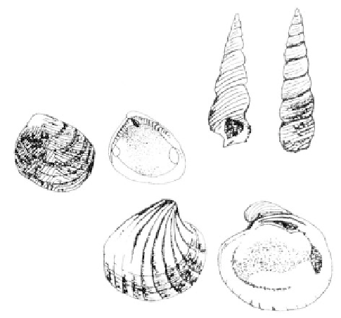
Eocene molluscs, southern Oregon Coast Range
(top to bottom
Turritella, Acila
, and
Venericardia)
As the island arc rotated progressively west-
ward, late Eocene swamps, wide coastal plains, and
shallow continental shelf conditions mark the third and
final phase of sedimentation in the subsiding forearc
basin. Since the Klamath Mountains had been previ-
ously planed down to a flat surface and the Idaho
source rocks were left far behind by the rotating block,
the early Western Cascades were the primary source
for sediments of the forearc basin. Ash and pyroclastic
deposits were in sharp contrast to the feldspar-rich
arkosic sands of the older Tyee Formation. In the Coos
Bay region, sands accumulated in an immense delta
spreading toward the north. Fossil plants and coarse
sediments from within the delta are enclosed in the
coal-bearing Coaledo Formation. Extensive near-shore
swamps characterized by subtropical plants are the
source of the coal. Thin-shelled delicate microfossils in
the overlying Bastendorff suggest intermediate depths
while the Tunnel Point sandstones reflect a shallow,
upper shelf environment.
Central and Northern Coast Range
In that portion of the ancient forearc basin
which later was to become the central and northern
Coast Range, silts, sands, muds, and volcanic debris
were deposited in the shallow middle Eocene seas,
while aprons of shell banks were built up around the
margins of the low volcanic islands and seamounts.
Deposited across the continental shelf, Yamhill muds
and silts, interspersed with Rickreall and Buell lime-
stone lenses, blanketed the Siletz River volcanics and
were in turn covered by about 5,000 feet of Nestucca
Formation deep water muds, sands, and silts mixed
A view of Sunset Bay in the foreground with
Gregory Point and Lighthouse Beach in the
center and Bastendorff Beach at the top.
Simpson Reef, composed of sandstones of the
Coaledo Formation, projects offshore
(photo courtesy of Ward Robertson).