Geology Reference
In-Depth Information
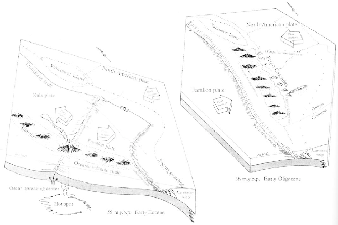
Accretionary island arc model for formation of the
Oregon-Washington coast block (after Duncan,
1982)
Geology
The foundation block of coastal Oregon and
Washington mountains began as a volcanic island chain
that collided with the North American plate. Some
distance to the west of Oregon and far beneath the
ocean crust, a hot spot generated deep sea lavas 64
million years ago. This volcanic source was situated
beneath an ocean spreading center straddling two
active tectonic plates. The Kula plate was being pulled
north to collide and slide below North America along
Washington and British Columbia. The Farallon plate
to the south was being overridden by southern Oregon
and California. As these two plates continued spread-
ing or pulling apart, a chain of undersea mountains,
strung out to the north and south. Forming a promi-
nent ridge on the sea floor, the line of volcanoes
occasionally projected above the water as low volcanic
islands. Close to the end of early Eocene time the
North American plate, moving westward, collided with
the recently formed islands and seamounts. With the
capture of the new landmass, North America had
grown about 50 miles in width. Volcanic rocks of this
island chain today form the backbone of the Oregon
and Washington coastal mountains and are the oldest
known rocks in the range.
More than half of the Oregon Coast is bor-
dered by sands resulting from the erosion of sea cliffs
or transported and deposited by rivers. While winter
beaches are stripped of sand by stormy conditions, the
summer months are the period when sands are rede-
posited. Sand builds up as dunes or spits when it is
trapped behind prominent headlands or man-made
projections. In spite of the transitory nature of dunes
and spits, houses, roads, and even entire towns have
been constructed here only to be threatened or de-
stroyed by severe winter erosion.
In the past the coastline has been subject to
effects of earthquakes and tidal waves or tsumanis. At
many coastal sites in Oregon sediments record land
subsidance as buried forests and mud-covered bogs that
resulted from powerful earthquakes. Similarly periodic
scouring of bays and coast areas by tsunamis is part of
the coastal erosion process. A final sculpting of the
land took place as the ocean eroded headlands and
filled bays creating a variety of spits, bay mouth bars,
islands, tunnels, and offshore sea stacks.