Geology Reference
In-Depth Information
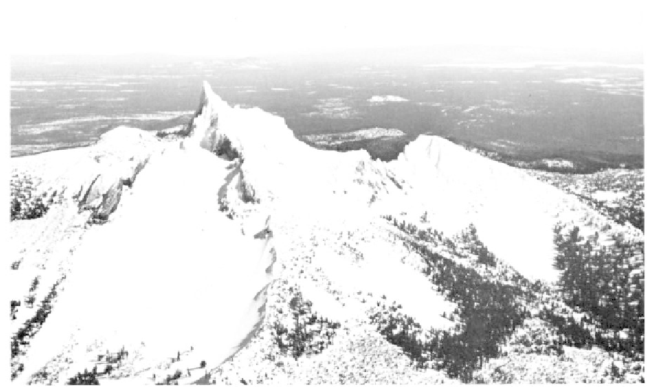
Oregon's rugged Mount Thielsen, called the lightening rod of the Cascades, rises 9,178 feet and forms
one link in the chain of mountains which extends from Mexico to British Columbia (photo Oregon State
Highway Department).
ing gear is needed to access many of them. Permission
shortly afterward. Historically smoke from the South
to explore the caverns should be requested from the
Sister was noted in 1853 by James Miller, a Presbyteri-
park superintendent.
an minister, who
"saw one of the Three Sisters belching
forth from its summit dense volumes of smoke."
Central High Cascades
To the north of Crater Lake, a line of sharp
Sand Mountain and Belknap Lava Fields
pinnacles in the central High Cascades belonging an
Very recent volcanic activity, in some cases
older interval of volcanism have been extensively
taking place only 400 years ago, has created a vast
altered by erosion. Of these, Mt. Thielsen is the most
region of black, cindery lava flows, buttes, and distinct
southerly followed by Broken Top, the North Sister,
lava fields in the Cascades between North Sister and
along with Mt. Washington and Three Fingered Jack,
Three Fingered Jack. Of these, lavas from the Sand
which both rise from broad bases to snow-covered
Mountain and Belknap flows are the most widespread.
spires. The glaciation that shaped these peaks contin-
The overall eruptive pattern of the region progressed
ues even today. The southern-most Cascade glacier is
from northwest to southeast with the first eruptions in
still active on the shady north side of Mt. Thielsen.
the Sand Mountain field and the latest from Collier
South of McKenzie Pass, the Three Sisters
Cone.
form a scenic cluster of peaks of rugged beauty. The
Slightly to the southwest of Mt. Washington,
South Sister, the highest of the cones at 10,354 feet,
a linear chain of 22 cinder cones and 41 separate vents
has a crater with a small lake. The Middle Sister
make up the Sand Mountain field. From the north, the
displays remnants of a crater, whereas the deeply
geographic arrangement of the cones includes Little
eroded North Sister shows no evidence of a former
Nash Crater, the Lost Lake group, Nash Crater, the
crater. On the south and southwest flanks of the South
central craters, the Sand Mountain cones, which are
Sister, an extensive single flow along with the dome at
the largest, and a group to the south. The alignment
Rock Mesa developed 2,300 years before the present.
reflects an underlying fracture zone which allowed
Clouds of ash and dust expelled from fissures were
gasses and lavas to reach the surface. Beginning around
followed by lava that covered over the vents. A second
4,000 years ago, volcanic vents discharged close to a
explosion of pumice then lavas from a series of new
cubic mile of lava accompanied by large quantities of
vents on the slopes of the South Sister took place
ash creating the rugged field of domes and flows. The