Geology Reference
In-Depth Information
may be water that is recirculating through a fault
system, the specific mechanism producing the springs
is unknown. Circulating from east to west, thermal
waters reach the surface in rocks of the Western
Cascades where erosion has cut deep valleys into the
older volcanics and where lavas of the younger Cas-
cades are absent. The springs, situated in this way at
the bottoms of deep canyons, serve as a division
between the older and younger Cascades. Hot springs
are virtually absent directly under the central portion
of the higher Cascade range. Heavily fractured younger
volcanic rocks here at the crest mix hot springs with
cold groundwater long before the waters reach the
surface.
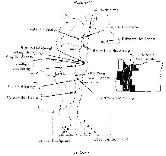
Jackson Hot Springs is the most southerly of
the Oregon system of springs in Jackson County, while
the warm springs at the old town of Swim in Clackam-
as County are at the northern end of the alignment.
Other thermal springs in the chain include Bagby Hot
Springs, Breitenbush Hot Springs, Belknap Springs,
Foley Hot Springs, McCredie Springs, and Kitson Hot
Springs. Temperatures of the spring waters range from
around 90 to 190 degrees Fahrenheit. Breitenbush and
Belknap Hot Springs have seen extensive commercial
development. With the largest discharge of water at
900 gallons per minute from 40 openings, Breitenbush
water temperatures reach 180 degrees Fahrenheit as
compared to 190 degrees Fahrenheit at Belknap
Springs.
The location of hot springs along the backbone of
the Oregon Cascades
comparatively low grade, and mining has been limited.
While production figures for Cascade mining
districts can only be estimated because of the lack of
records, the total revenues from all minerals extracted
since 1858 is $1,500,000, keeping in mind that the price
of gold was much lower at that time.
Geothermal potential in the Western Cascades
is relatively low, while to the east of the thermal
boundary higher groundwater temperatures indicate the
potential for geothermal exploitation. Of all the
regions in the range, Mt. Hood has been thoroughly
examined for geothermal resources. The continued
tectonic history of the mountain from a number of
volcanic centers implies a high heat flow and hydro-
thermal systems. Although there is little evidence of
high temperature waters circulating through near-surf-
ace faults here, Mt. Hood remains a target for further
exploration.
Geothermal Resources
Between the High Cascade and Western
Cascade ranges, a belt of hot springs marks a major
heat flow change that takes place very abruptly within
a distance of less than 12 miles. Low temperature
gradients in the Willamette Valley and adjacent
Western Cascades increase to high temperatures on the
eastern side of the Western Cascades and High Cas-
cades. The reason for the change in heat flow is
unknown since the heat source hasn't been located, but
higher temperatures may result from a combination of
warm groundwater and partially molten material under
the Cascade area east of the boundary.
On the surface, the thermal boundary is
manifest by springs. Those springs in the central
portion of the Cascades have higher water tempera-
tures than those at either end. Many of the thermal
springs in the Cascades are located along faults where
superheated waters migrate up along the fractures.
Although the hot springs that appear on the surface
Features of Geologic Interest
Columbia River Gorge
The Columbia gorge is 75 miles of geologically
spectacular scenery along the Columbia River from the
narrows at The Dalles west to Portland. Mt. Hood in
Oregon and Mount St. Helens and Mt. Adams in
Washington overshadow the canyon where it cuts
through the Cascades. In its long history, the ancestral
channel was repeatedly filled with lava or blocked by
landslides and ice dams, but the waters have surmount-
ed these obstacles quickly by frequently changing