Geology Reference
In-Depth Information
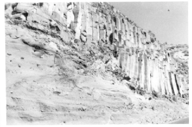
Intracanyon flow of columnar
Deschutes Formation basalts
over a valley cut into ash
and cinders at the entrance
to The Cove Palisades State
Park. (Photo Oregon Dept. of
Geology and Mineral Indus.)
The filling of the Deschutes Canyon by the Metolius Springs
waters impounded behind Pelton and Round Butte One of the swiftest flowing and shortest rivers
dams had unusual side effects. As the lakes filled and in the west, the Metolius begins with waters gushing
the local groundwater table rose, many new warm from the springs at the base of Black Butte to form an
springs emerged. These thermal springs include 14 in "instant river". Situated in the southwest corner of
Willow Creek canyon alone. Water temperatures of the Jefferson County about 30 miles northwest of Bend,
springs average around 60 degrees Fahrenheit, which is Metolius Springs are at the junction of the Western
slightly warmer than most other thermal springs in the Cascade province, the High Lava Plains province, and
region. The presence of the springs has also triggered the Deschutes-Columbia Plateau. The springs issue
a dramatic change in the modern flora in the immedi- from two openings at the foot of Black Butte about 200
ate vicinity. yards apart, merging after a short distance to flow
northward. Total output from the springs measures
Balanced Rocks 45,000 gallons per minute, and the water temperature
John Newberry, on a railroad exploring expedi- is a chilly 48 degrees Fahrenheit.
tion to Oregon in 1855, examined the Deschutes area Geologic events associated with the origin of
in great detail, recording his trip in copious notes. One Metolius Springs began with block faulting. Tension
of his discoveries was a group of precariously balanced along a north-trending fault caused a block to drop
rocks on the north-facing slope of the Metolious River down forming the graben valley of the Metolius. The
just before the river enters Lake Billy Chinook. The high Green Ridge fault scarp along the eastern side of
balanced rocks of this striking phenomenon, weighing the valley blocked the flow of surface water and chan-
over a ton each, are perched atop tapering pinnacles 20 neled it toward the north and around the end of the
to 30 feet high. The rocks, resembling the top knots of ridge creating an ancestral Metolius River. About
Easter Island statues, are more massive and greater in 500,000 years ago, eruptions from vents along the fault
diameter than the pillars which support them. Com- escarpment built up Black Butte cone straddling the
posed of volcanic basalt and interbedded sedimentary Metolius Valley and covering the ancient river drain-
siltstones and sandstones of the Deschutes Formation, age. The waters which once flowed above ground now
the columns are the product of differential weathering. percolate through sands and gravels in the old channel
Erosion rapidly removed the softer lower layers and left beneath the volcano before they reappear above ground
the resistant cap, which armors the striking columns as Metolius Springs.
that stand out in relief. Close by, another group of
balancing rocks, named Button Head Rocks, are not as
high or as massive.