Geology Reference
In-Depth Information
Geology
Miocene
Small exposures of Paleozoic and Mesozoic
rocks as well as parts of the Eocene, Oligocene, and
Miocene Clarno and John Day formations that extend
into the Columbia-Deschutes province from the south
are treated with the Blue Mountains province.
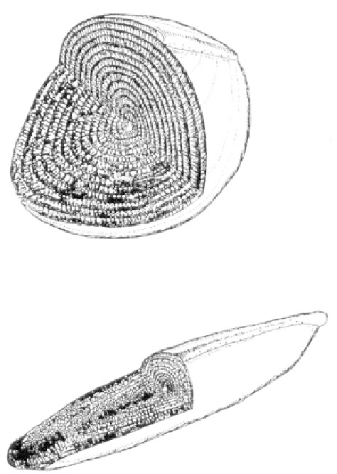
The oldest rock known from the Columbia-De-
schutes province is a single stone discovered near the
base of Gray Butte in Jefferson County. Fusulinids, or
fossil protozoa, extracted from the loose boulder were
dated as late Permian, approximately 250 million years
old. More remarkably, these fossils are of a variety
typical only to the eastern Pacific regions of Japan,
Timor, and China. Although the affinity of this rock
was puzzling when it was discovered in the middle
1930 s, with the present knowledge, it can be related to
one of the many exposures of displaced terranes found
today in the eastern Blue Mountains. The stone was
evidently eroded from one of the terranes before being
transported by streams to the western part of the
Columbia-Deschutes province.
Geologic study of the Columbia Plateau
focuses upon the basalts that flooded this province, an
episode that took place during the middle to late
Miocene, 17 to 6 million years ago. Eruptions occurred
on the average of one flow every 35,000 years with an
output per flow of over 100 cubic miles of basalt.
Larger eruptions, however, encompass over 500 cubic
miles of basalt for a single flow. Thick, successive
outpourings of lava spread over the landscape often
moving at a speed of up to 30 miles an hour to form
the Columbia River basalts, the primary group in the
plateau today. Covering an area only slightly less than
the entire state of Washington, the total volume of
basalt, which was over 42,000 cubic miles, would be
enough to construct a wall of lava one mile wide and
almost 2 miles high around the earth. The thickness of
individual flows is variable, but several flows up to 200
feet are known. Spreading across the Deschutes-Colum-
bia River Plateau, the spoon-shaped mass of basalt is
over 3 miles thick beneath Yakima and Pasco, Wash-
ington, thinning to the south from a mile thickness
along the Columbia River to a feather edge within the
Blue Mountains province. This suggests that the lava
was extruded into a basin that subsided progressively
with succeeding flows.
Some of the most extensive of the Columbia
River flows may have taken decades to cool and
harden. Cooling proceeds in a lava flow from the top
down and from the bottom upward. Typical lava flows
in cross-section have two distinct layers that have been
named after parts of Greek temples. The lower portion
or colonnade is so-called because the basalt has cooled
and contracted to form columns perpendicular to the
cooling surface below. The remaining section of the
flow, which constitutes up to 4/5 of the entire mass, is
the entablature with multiple directions to the columns.
Near the top of the entablature, the basalt may be
vesicular from gas which has come out of solution in
the molten lava to form bubbles. Often these gas
bubbles leave long vertical tubes or pipes through the
lava to mark where the gas escaped.
There is disagreement with respect to exactly
how lava in flood basalts flowed. As the lava moved, a
thin surface skin may have hardened only to break up
so that the new flow would look like a wall of broken
rock rising up to 10 stories high. Inside the flow the
lava was fluid, but at the base, along the top, and at the
snout, it is armored by sharp, blocky pieces of broken,
cooled basalt. The veneer of broken chunks atop the
lava tends to roll over as the flow spreads, developing
a steep, irregular front. As the lava moves farther from
its source, the edge becomes progressively thinner until
it is only a few stories high. At some point the lava,
Comparison of Permian fossil fusulinids from the
Orient (upper) and North America (lower)
(specimens are 1/2 inch in length)