Geology Reference
In-Depth Information
Harney Basin. The remarkable Rattlesnake ash-flow
tuff, which extends to the vicinity of John Day 90 miles
to the north, also has source vents in the Harney Basin.
These formations are covered by alluvium and lake
deposits eroded largely from the volcanic rocks of the
adjacent uplands. At the outer margins of the basin,
sand and gravel predominate, while silts and clays fill
the center. Younger lavas from Diamond Craters
along with some Pleistocene basalts cover these sedi-
ments. Within these deposits thin but well-defined
layers of 6,900 year old Mazama ash lie three to six
feet below the surface.
Shallow, ephemeral Malheur and Harney lakes,
and smaller Mud lake which connects the two, are
located in the south central portion of Harney Basin.
During wetter conditions existing in the Pleistocene, a
huge body of freshwater, ancient Lake Malheur,
occupied the basin and extended all the way to Burns.
The lake originally drained to the east along the south
fork of the Malheur River and from there to the Snake
River until the outlets near Princeton and Crane were
dammed by a lava flow. As warmer, dryer conditions
prevailed, about 10,000 years ago, the lake rapidly
shrank in size creating the present series of smaller
lakes, playas, and marshes. Lake Malheur, at its highest
water level, was probably never more than 50 feet deep.
Even historically Malheur, Mud, and Harney
lakes were not always joined. Explorer Peter Skene
Ogden observed in 1826 that
"a small ridge of land, an
acre in width, divides the freshwater from the salt lakes".
About 1880 Malheur Lake topped the ridge and overfl-
owed into Harney Lake. Today these lakes frequently
double or triple in size during wet spells or decrease to
virtually nothing in a dry period. Flooding during three
years of record rainfall in 1984 caused the three lakes,
normally covering 125,000 acres, to expand to 175,000
acres. Periods of extreme drought are not abnormal to
these lakes, and prior to 1930 they became virtually dry
due to low rainfall.
Malheur, Harney, and Mud lakes have been
designated as the federal Malheur National Wildlife
Refuge, a home for thousands of wild birds, native
plants, and animals.
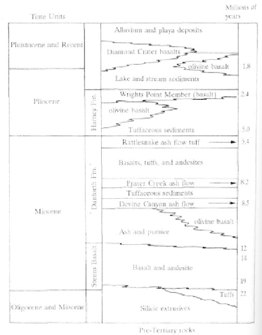
Correlation chart of High Lava Plains stratigraphic
units
a number of perennial springs near Hines, Warm
Springs valley east of Burns, and around Harney and
Mud Lakes to the south. Water temperatures near
Hines reach a high of 82 degrees Fahrenheit with
temperatures diminishing outward from there. Some of
the highest temperatures occur in spring waters south-
west of Harney Lake where 90 to 154 degree Fahren-
heit waters indicate the presence of a thermal system.
Several springs here have commercial facilities, and
one, Radium Hot Springs, popular since the 1890s, is
the largest warm water pool in the state.
Features of Geologic Interest
Fort Rock, Hole-in-the-Ground, Big Hole
Distributed widely on the High Lava Plains,
maars and tuff rings resulted when upward moving lava
in the crust encountered underground water with
devastating effects. Upon contact with the cooler water,
the hot lava exploded catastrophically, creating a
symmetrical, circular crater. Rocks and ash from the
eruption, thrown into the air, settled close to the crater
building up a high rim or tuff ring. Saucer-shaped
maars are shallow explosion craters that are fed by a
Geothermal Resources
Percolating from deep within the crust through
cracks and fractures, heated water reaches the surface
as warm springs. Scattered over the Harney Basin,
almost all thermal springs are aligned along faults.
Although some springs record much higher readings,
the average temperature of the waters is between 60
and 82 degrees Fahrenheit. Thermal waters, ranging
from 64 degrees to 154 degrees Fahrenheit issue from