Geology Reference
In-Depth Information
of the main crater. The extremely fluid pahoehoe lava
from the eruptions produced a lumpy, ropy surface of
ridges and pits as well as deep fractures and channels
in the lava crust. One large section of the crater wall
was torn away by explosions, and after activity ceased
volcanic debris filled much of the remaining spectacular
260 feet deep crater.
The flowing lava followed the drainage pattern
of Cow Creek, developing a meandering lava tube
system deep within the flow. Once the liquid magma
had drained away, a hollow tunnel was left within the
cooled lava crust. Two large pits, north of the main
crater open into the lava tube system. Immediately
south of the Jordan Craters, Clarkes Butte, Rocky
Butte, and Three Mile Hill are small shield cones that
sent forth lavas about the same time as the Jordan
cones.
Saddle Butte Lava Tube Caves
Volcanism from Saddle Butte tuff cones that
erupted just after the Steens basalt produced sinuous
lava tube caves near Burns Junction in Malheur
County, a short distance southwest of Jordan Craters.
This group of caves can be traced for 8 1/2 miles
through the Saddle Butte lava field. At one time the
caves were a continuous long chain of interwoven
tunnels before parts of the tube failed. Collapsed
sections of the cave create winding deep trenches in the
lava field, the longest measuring well over one-half
mile in length.
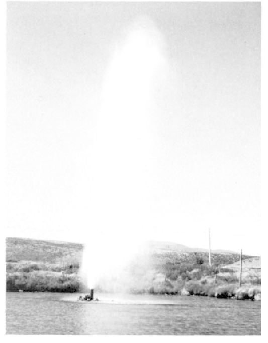
A geyser at Hunter Hot Springs located north of
the city of Lakeview began erupting in October,
1923, while a well was being drilled at this site
(photo Oregon Dept. Geology and Mineral Indus-
tries).
Features of Geologic Interest
Jordan Craters
Although several areas of Malheur County
have dramatic volcanic features, the Jordan Craters
lava beds approximately 36 miles southwest of Adrian
are of prime interest because of the recent volcanic
events that took place here. The 28 square miles of
Jordan Craters lava field has been designated a Natural
Resource Area in order to preserve its unique charac-
ter.
Before volcanism began, the flat plateau, now
occupied by the lava field, was part of the Cow Creek
drainage. Lying in a depression on the Owyhee Plateau,
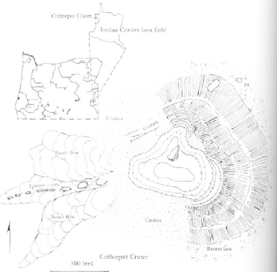
the first to erupt was a ridge of small spatter cones in
the northwestern corner of the field, aligned along a
fault trending 1,000 feet toward Coffeepot Crater. This
activity between 4000 and 9000 years ago was followed
by basalt flows from Coffeepot Crater, one of the
youngest and largest of the Jordan Craters complex.
Basalts covered about 28 square miles mainly southeast
Coffeepot Crater, on the northwestern edge of Jor-
dan Craters in Malheur County, produced most of
the lava in the field (after Otto and Hutchinson,
1977).