Graphics Reference
In-Depth Information
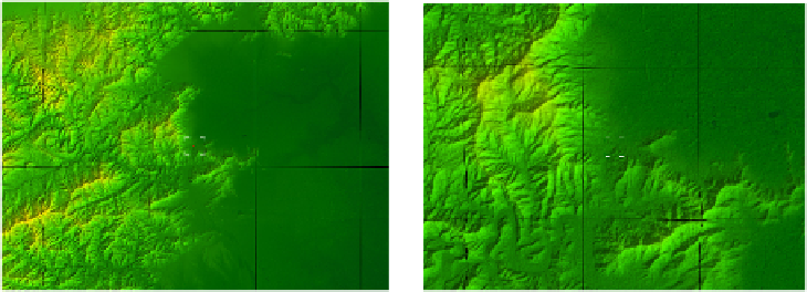
Fig. 12.
Shading effect (LOD at level 7)
Fig. 13.
Shading effect(LOD at level 8)
azimuths of the sun = 135° azimuths of the sun =135°
altitude of the sun = 30° altitude of the sun =30°
6
Conclusions
In today's hardware conditions, the use of static LOD can meet real-time. While
drawing 21 terrain blocks, the frame rate of prototype system can maintain at 29fps.
The prototype experiment shows that the application of the visualization technique
feasibility is based on XNA.
At present, the shortcoming in the prototype system is that the scheduling
algorithm for terrain blocks is not optimized. If the frame rate was improved, system
can add other functions, such as terrain analysis.
In our further research, we will use the self-defined lighting model by HLSL, and
we will study the relationship of lighting parameters.
Acknowledgments.
Thanks to NASA and CGIAR-CSI! Without these public DEM
data provided by them, these ideas cannot be achieved! Thanks to the physics group
of Shanghai Eighth Middle School! Their annotation and experience made the
learning of XNA easy!
References
1.
Wang, J., Sun, Q., Wang, G.: The principles and methods of cartography.
地图学原理与方
法
. Science Press, Beijing(2011)
2.
Li, Z., Zhu, Q.: Digital elevation model.
数字高程模型
. Wuhan University Press, Wuhan
(2001)
3.
Zhou, Q., Liu, X.: Digital terrain analysis.
数字地形分析
. Science Press, Beijing (2006)
4.
Li, Z., Wei, E., Wang, Z.: Space Geodesy.
空间大地测量学
. Wuhan University Press,
Wuhan (2010)
5.
Grootjans, R.: XNA 3.0 Game Programming Recipes: A Problem-Solution Approach.
Apress, Berkeley (2009)
Search WWH ::

Custom Search