Travel Reference
In-Depth Information
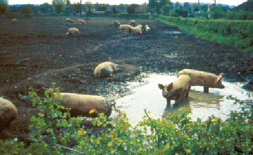
field. From beyond the hawthorn hedge come the satisfied grunts and squeals of a herd of
pigs wallowing in a pool just out of sight but not out of range of sound or smell.
From here the gradient eases as the canal distances itself from the foot of the Chilterns.
This Vale of Aylesbury countryside is flat and unspoilt, with the traditional English open-
farming character. To the south the scarp slope of the Chilterns rises steeply to the
beechwood-clad Coombe Hill, the highest point in the Chilterns standing at 260m, 170m
above the vale here. Interestingly, 5km to the south-west is another Coombe Hill that exactly
matches the 260m height of this one, the latter being topped by a monument and hiding
Chequers, the country residence of the Prime Minister.
Happiness is pig-shaped. The lock's neighbours at Wilstone
.
Two Puttenham locks draw attention to the village of Puttenham to the north. One of the
church's vicars was Christopher Urswick. As Richard III's Recorder of London, he supplied
information to the exiled Henry Tudor, later marrying him to Elizabeth, the daughter of Ed-
ward IV.
The village of Aston Clinton was developed largely by the Rothschilds who settled here in
1851 and proceeded to spend some of their great wealth in the area.
Lines of communication converge with the canal as it approaches Aylesbury. To the left
lies the A41, the current form of the Roman Akeman Street, while to the right is the course
of a former railway that ran from Aylesbury to Cheddington.
The land becomes very low-lying around Broughton Lock, giving extensive views, and
there has been bank restoration work, sheetpiling and fabric membrane laid on top of the em-
bankment to give stability.
The canal probably follows a former line of the Bear Brook that now runs to the south,
possibly diverted to serve a mill. The brook's present course is on the side of a slope and
in times of flood it overflows down towards the canal. A flood relief scheme for Aylesbury