Geoscience Reference
In-Depth Information
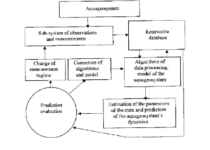
Fig. 9.3 Principal block-scheme of the adaptive regime of the hydrophysical experiment
complex of methods to solve these problems. A combination of the hydrophysical
monitoring problems with the system of the automated data processing is only
possible in an adaptive regime. It is shown schematically in Fig.
9.3
.
The monitoring can be point wise and areal. In the
first case the data processing
is connected with the use of a number of algorithms providing an assessment of the
required set of parameters without consideration of spatial scales of the process or
object under study. In the second case the system of data processing requires special
methods aimed at reducing their variability and forming a spatial image based on
measurements episodic in time and fragmentary in space. In this case, it is essential
to choose the scales of the cartographic grid and to correlate it with the problems to
be solved. Only then can one guarantee a certain level of reliability in the assess-
ment of the state of the aqua-geosystem.
Algorithms of formation and processing the spatial databases are approved in the
GIS-technology. However, there exists a gap between traditional methods of GIS-
technology and models as an instrument of prediction. To
fill up the gap, the
selection of the matrix structures-identi
ers with the hierarchical topology both in
space and in the elemental
filling of the aqua-geosystem model is made. Each
element of the identifier describes in the symbol space the image of an element
(fragment) of the system under study. In other words, the territory
ʩ
is presented in
the form of the hierarchical spatial structure:
Search WWH ::

Custom Search