Geoscience Reference
In-Depth Information
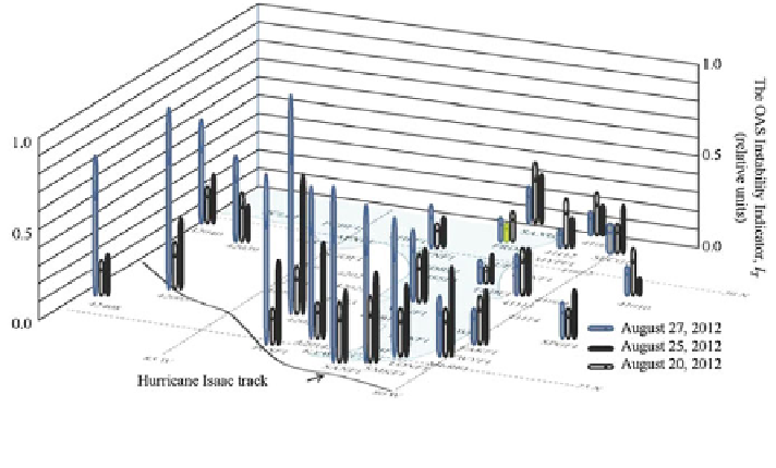
Fig. 7.24 Instability indicator calculated for August 20, 25 and 27 of 2012 using meteorological
data from separate NDBC weather stations located in the Florida zone
In addition, the Table
7.9
presents the calculation data for restricted list of
weather stations. It is worth to note that the result obtained is the same with the case
of all weather stations located in the coastal zone of Florida Peninsula taken into
consideration. It is seen that zone
Ω
1
is the parameter for the subsequent control of
the OAS according to the scheme shown in Fig.
7.14
.
7.6 Predicting the Path of a Tropical Cyclone
Storms, hurricanes, and typhoons are examples of natural instability that occurring
in the ocean-atmosphere system and cause catastrophic events connected with
deaths and economic losses. Many authors try to forecast the extreme processes in
the ocean-atmosphere system. To solve this problem, a network of meteorological
stations has been built up including the TAO/TRITON/PIRATA system of buoy
stations. However, forecasting the development of a tropical cyclone is a complex
problem that includes several elements: track forecasting, intensity forecasting,
rainfall forecasting, and storm surge forecasting. Another, possibly even more,
dif
cult task is the detection of the origin of a tropical cyclone.
The methods used in forecasting tropical cyclones have changed with the pas-
sage of time based on different information sources including satellites. The base of
these methods is the tropical cyclone forecast models of which there are mainly
three types: statistical, dynamical, or combined statistical-dynamic. Such models
utilize meteorological data to calculate paths and intensities only. New forecasting
techniques have been developed during recent years by Soldatov (2009b) in
Search WWH ::

Custom Search