Geoscience Reference
In-Depth Information
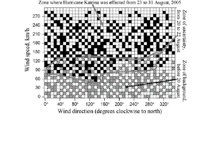
The use of TAO/TRITON&PIRATA/RAMA data in the monitoring regime with
the employment of the percolation model is equivalent to the scheme of the point {xi}
i
}
walk within the sites of
ʞ
d
. In the case d = 2 we consider the wind speed, x
2
, and the
atmospheric pressure, x
9
, which are two meteorological parameters that can be
expected to vary very strongly in the presence of a tropical cyclone. In Fig.
7.14
we
plot the hourly values of x
2
and x
9
for August 2005 during which Hurricane Katrina
formed, developed and dissipated. The random walk of point {xi}
i
}in
ʞ
2
(x
9
,x
2
)isa
function of a changing meteorological situation that is characterized by the transition
from the background to the state when a tropical hurricane occurs. In this diagram the
existence of the tropical hurricane within the time period T is characterized by a
double percolation transition of the point {x
9
, x
2
} through zone
2
1
2
N
2
between zones
N
3
2
. An analysis of the motion of the point {x
9
, x
2
} is connected with the
assessment of probability characteristics for the drift of its projection on the direction
ʷ
and
N
2
of the zone
N
2
boundaries. The drift
ʽ
of this projection from some initial position A
represents the sum
ʣ
ʽ
of a random number of the components.
The distribution structure of zones in the plane
ʞ
2
for the Bahamas in August
2
2
2005 (Fig.
7.14
) has speci
c elements bounded by the zone
N
in which the event
leading to Hurricane Katrina was arising but
it was not detected. When
2
, the meteorological situation was characterized as the background up
to 20 August 2005. Hurricane Katrina was recorded in the morning of 23 August
2005 by Landsat and other meteorological satellites above the south-eastern sector
of the Bahamas and after that it was classi
ð
x
9
;
x
2
Þ2N
r-
Simpson scale. Moving to the Gulf of Mexico in the direction towards New
ed in the
first category by the Saf
Fig. 7.14 Cluster structure of the meteorological situation that took place during August 2005 in
the region of the Bahamas from the data of Meteorological Station No. SPGF1 (26
°
42
′
16
″
N,
78
W). Hurricane Katrina formed on 23 August, hit New Orleans on 28 August and
dissipated on 30 August, 2005
°
59
′
40
″
Search WWH ::

Custom Search