Geoscience Reference
In-Depth Information
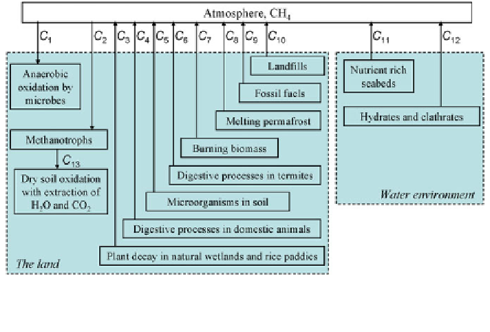
Fig. 6.28 Global methane cycle in the atmosphere-ocean-land system
As it is concluded from Table
6.24
, where existing evaluations of carbon res-
ervoirs and
fluxes are divided by categories.
Model of global biogeochemical carbon cycle is to account these reservoirs and to
describe
fl
fluxes are given, all carbon pools and
fl
fluxes between them. It is evident, that existing environmental databases
and knowledge can not deliver detail input information for this model about the role
of every plant, animal or microbe, every photosynthesizing leaf or algae, every
oceanic aquatory, lake, pond and puddle, every landscape, etc. Figure
6.28
de
fl
nes
some level of carbon cycle complexity and gives the possibility to describe it on
restricted spatial and object level, focusing only on the processes that are most
important at the regional or global scale. Unfortunately, series of carbon
fl
uxes have
very approximative assessments including, for example,
uxes F
3
and F
26.
In
accordance with this, spatial structure of carbon cycle depends on the information
that characterizes regional and global databases on the soil-plant formations and
oceans.
Spatial ecology proposes different fragmentations of the land ecosystems and
oceanic aquatories. Spatial distribution of soil-plant formations is characterized by
series of geographical grids. For example, soil geographical databases of Europe
and Canada are characterized by scale 1:1.000.000. Such databases of many
countries are formed on the principle of typical landscapes distinguishing agricul-
tural, forested, economic and other types. New harmonized global soil database of
FAO covers over 15,000 different units of soil mapping that combine existing
regional and national updates of soil information worldwide in framework of
1:5,000,000 scale. Existing global GIS datasets are the most acceptable for the
synthesis of global carbon cycle model.
fl
Search WWH ::

Custom Search