Geoscience Reference
In-Depth Information
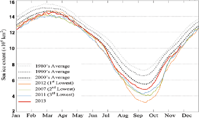
Fig. 5.8 Arctic sea ice extent during year (
http://www.ijis.iarc.uaf.edu/en/home/seaice_extent.htm
)
the observed data, SAT has increased during the last decades over most of the
Arctic. One of the regions where a warming has taken place is northern Alaska
(especially in winter and in spring). In this connection, Stone et al. (2002) have
analyzed the data on climatic changes in the North of Alaska to reveal their impact
on the annual trend of the snow cover extent (SCE) and the impact of SCE changes
on the surface radiation budget (SRB) and SAT. The NASA/GEWEX SRB
Release-3.0 data sets contains global 3-hourly, daily, monthly/3-hourly, and
monthly averages of surface and top-of atmosphere (TOA) longwave and short-
wave radiative parameters on a 1
°×
1
°
grid.
The Northern Hemisphere EASE-Grid 2.0 Weekly Snow Cover and Sea Ice
Extent Version 4 product combine snow cover and sea ice extent at weekly intervals
from 23 October 1978 through 31 December 2010, and snow cover alone from 03
October 1966 through 31 December 2010. Snow cover extent for this data set is
based on the NOAA/NCDC Climate Data Record (CDR) of Northern Hemisphere
(NH) Snow Cover Extent (SCE) regridded to the EASE-Grid. The NOAA/NCDC
CDR of Northern Hemisphere Snow Cover Extent data were derived from the
manual interpretation of AVHRR, GOES, and other visible-band satellite data
(Helfrich et al. 2007; NOAA 2012). Sea ice extent is regridded to EASE-Grid from
Sea Ice Concentrations from Nimbus-7 SMMR and DMSP SSM/I-SSMIS Passive
Microwave Data. Designed to facilitate the study of Northern Hemisphere seasonal
fl
fluctuations of snow cover and sea ice extent, the data set also includes monthly
climatologies, describing the average extent, probability of occurrence, and
variance. Data are provided in
fl
flat, unsigned binary
files and are available via FTP.
Search WWH ::

Custom Search