Geoscience Reference
In-Depth Information
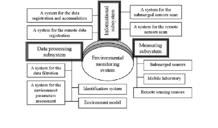
Fig. 4.27 Principal structure of the system of environmental monitoring in reference to the gas
condensation deposits zone
the data processing subsystem should reduce the conditions made by the
demands on the measuring subsystem;
the data presentation subsystem should allow to the gas condensation deposit
administration the possibility of multi-shape assessment of the environment
state;
the monitoring system should be combined with other informational systems
(regional, national, and international).
The experience of synthesis of GIS and expert systems having the function of
nature-protection calls for the necessity of observing the conception and subsequent
stages under the realization of the natural environmental monitoring systems
(Krapivin and Shutko 2012) to propose the SEM infrastructure in the form repre-
sented by Fig.
4.27
.
The environmental monitoring system software package must be oriented to the
realization of an algorithmical set giving the possibility to realize the following
minimal set of functions:
integrated assessment of the ecological state of the aquatory;
assessment of the ecological state of the aquatory for each of its components;
assessment of the integrated ecological state of the aquatory in the spot, on the
square area and for the total space;
identi
cation of the pollution source; and
predictional assessment of the ecological state of the aquatory.
The answers to questions arising under the realization of these functions and the
decision making demand transformation of the measurement data in acceptable
format. This can be realized by means of the software package listed below:
Search WWH ::

Custom Search