Environmental Engineering Reference
In-Depth Information
FIG
101.
The marsh at Llanrhidian, looking west towards Landimore along the ditch at the edge of the field system.
(Harold Grenfell)
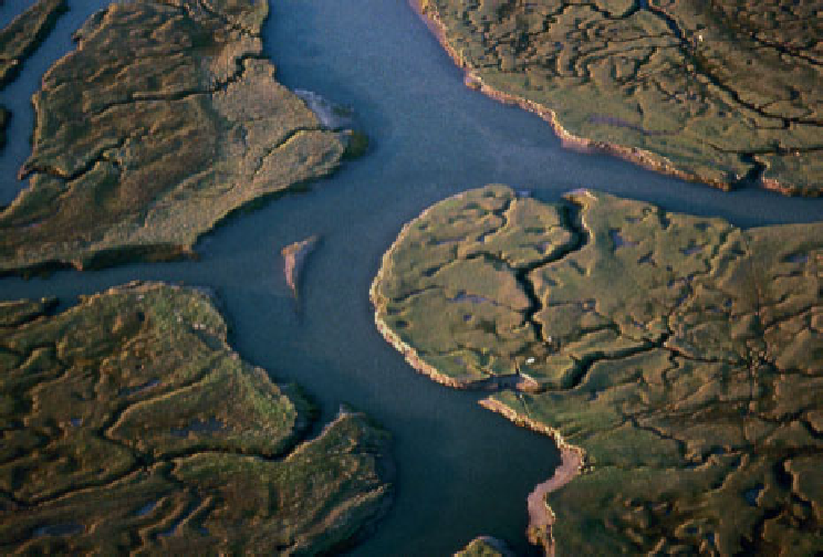
FIG
102.
Creek patterns on Landimore Marsh. (Peter R. Douglas-Jones)
Development of the marshes took place naturally until the mid eighteenth century when a breakwater,
or 'training wall' of slag blocks was built diagonally across the low-water channel of the river to aid nav-
igation to the port of Llanelli. The aim of the training wall was to use the natural power of the tide to
scour a channel to the port. The wall succeeded in its objective, but it also produced changes to the over-
all regime in the inlet and estuary and as a consequence areas of sediment deposition and erosion were
drasticallyaltered.Oncethereweremanydifferentchannelsintheestuary,todaythereisonlyone.InJuly
1764 John Wesley, travelling to Gower on one of his preaching tours, was able to ride across the estuary
from Kidwelly with a local guide. Once the wall was completed this became impossible.
Marsh on the southern side of the estuary extended at the expense of the sand flats, and the moorings
at Pen-clawdd, formerly served by a channel deep enough for seagoing vessels, rapidly became too shal-
low for use. Old maps and documents show that between 1790 and 1900 the marshes increased in area by
307 hectares and by 1960 had covered a further 252 hectares. The end of Llanelli as a port in the early
part of the last century meant that the training wall fell into disrepair and it was finally breached in the
1950s. The estuary is still in the process of reverting to the natural pattern of water movement, with the
main channel gradually moving south again. As the wall continues to collapse this process will continue
until a situation close to the original sediment distribution is reached.
The vegetation of salt marshes is usually confined to the region between the mean high water of neap
tidesandextreme highwaterofspringtides,andlikeotherintertidal communities itshowsamarkedzon-
ation at different levels. One of the features of the area often remarked upon by visiting naturalists is the
undisturbedandcompletesuccessionfromopensandandmudflatsthroughpioneersaltmarshcommunit-
ies to upper salt marsh and dunes, marshy fields, or even woodland. The greatest diversity of plant spe-