Agriculture Reference
In-Depth Information
One current experimental design tackles
the links between soil functions and soil
threats, with a network of CZOs that is organ-
ized conceptually along gradients of parent
material, climate and land-use intensity
(
Fig. 6.5.
; Banwart
et al
., 2011).
A meeting of international CZO teams
in late 2011 identified
60
sites in
25
coun-
tries worldwide with either ongoing or
planned research that aligned with the crit-
ical zone framework and CZO research ap-
proach described here. A particular point of
discussion was the potential to tackle envir-
onmental change research by studying soil
and other critical zone processes along
planetary gradients of environmental change
(outlined by Banwart
et al
., 2013). In broad
terms, international networks of CZOs offer
the potential to achieve several key advances
related to soil functions and soil carbon
management:
1.
Field investigations to ground truth re-
mote sensing data and proxies.
2.
Nested measurements of soil process
rates and their variation with environmen-
tal conditions.
3.
Data sets to develop and test modelling
and simulation methods to forecast soil
functions.
4.
Integrating multidisciplinary research
efforts that link soil functions with ecosys-
tem services, their social and monetary
valuation and assessment of adaptation
strategies for land, water and biomass re-
sources during environmental change.
Shale,
undisturbed soils
Disturbance
gradient
Shale
hills
CZO
Plyn-
limon
Granite,
undisturbed soils
Sierra
Nevada
CZO
Boulder
Creek
CZO
Streng-
bach
BigLink
CZO
Kiridla
Granite,
disturbed
soils
Lysina
CZO
Limestone,
disturbed soils
Lithology
gradient
Koiliaris
CZO
Sandstone,
disturbed soils
Red soils
Alluvial,
disturbed soils
Fuchsen-
bigl
CZO
Clear
Creek
Climate gradient
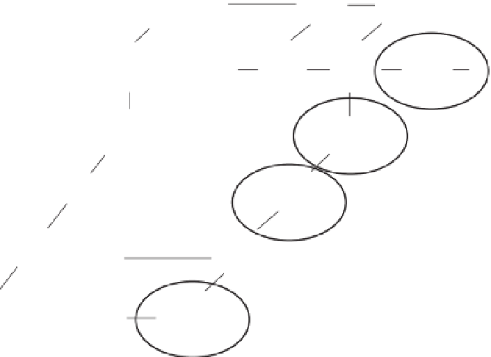
Fig. 6.5.
Conceptual framework for experimental design using networks of Critical Zone Observatories
(CZO) to study soil functions and soil threats along environmental gradients of climate, lithology and
intensity of land use (disturbance) (see Banwart
et al
., 2011). Each block represents a CZO or associated
field site. The circled sites represent different stages in the development of soil functions; BigLink CZO is
at the forefield of the Damma Glacier in central Switzerland and represents the initial soil formation as the
ice has retreated during the past two centuries. The Lysina (Czech Republic) and Fuchsenbigl (Austria)
CZOs represent managed forest plantation and arable farming, and the Koiliaris (Crete, Greece) CZO
represents mature land use during millennia of agriculture and imminent threat of desertification due to
loss of soil organic carbon and future scenarios for warming of the Mediterranean Basin during this
century. The additional sites represent a greater geographical spread of sites and environmental
conditions that provide a wider envelope of data on soil processes.


Search WWH ::

Custom Search