Geology Reference
In-Depth Information
Arctic Ocean
MAR 15 / 25 MARS
2014
Eastern
Arctic
Western
Arctic
Hudson
Bay
ICE IN CANADIAN
WATERS
GLACES DANS
LES EAUX CANADIENNES
Legend / Légende
Loss Than 1/10
oins do 1/10
1-3/10
4-6/10
7-8/10
9-9+/10
10/10
1-3/10
4-6/10
7-8/10
9-9+/10
10/10
Land
No Date
Teme
Aucunos donnócs
Scale / Echelle
200
1000
200
400
600
800
1000 km
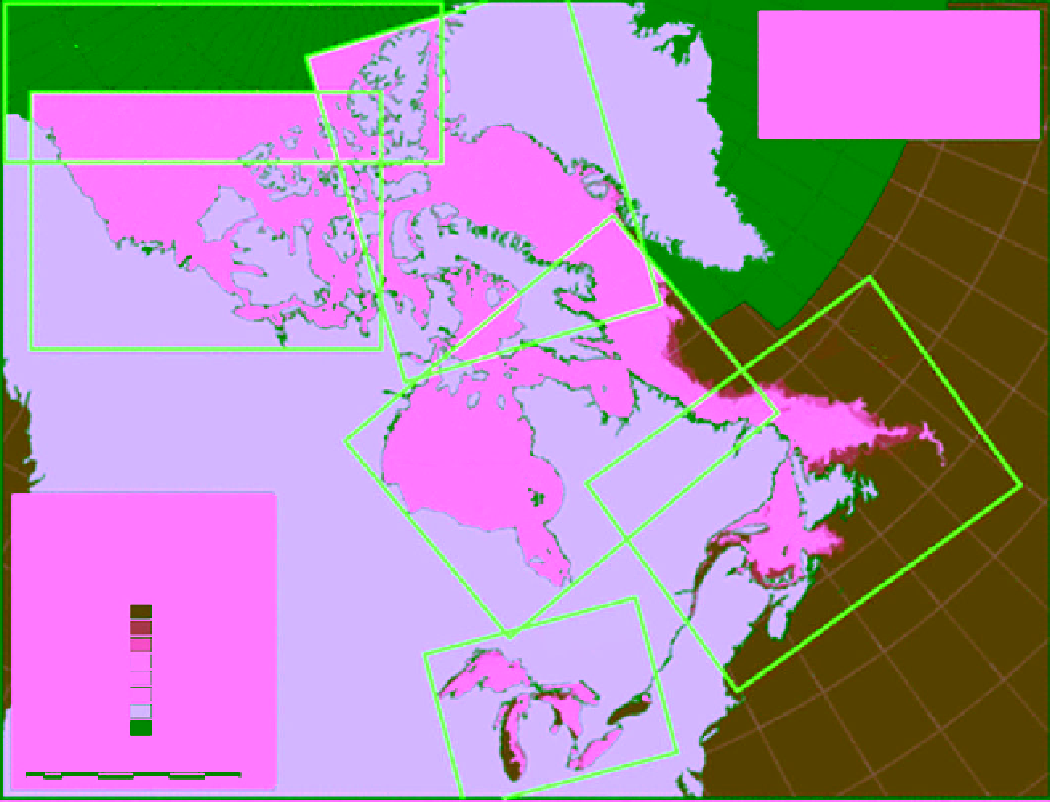
Figure 11.1
Reference map of the Canadian Arctic and sub‐Arctic showing the six regions of ice mapping by the
Canadian Ice Service. The map shows the weekly ice concentration (in tenths) in five regions (excluding the Arctic
Ocean region) on 15 March 2014. Maps are updated on a daily basis using the most recent regional and daily ice
charts. Updates and detailed maps for each region are accessed online at http://www.ec.gc.ca/glaces-ice.
the continual decrease of ice cover and the expected
opening of the ice‐free Northwest Passage for marine
traffic, if the ice decreasing trend continues [
Howell et al.
,
2013b]. The eastern Arctic region includes the Lincoln
Sea, Baffin Bay, and the eastern part of the CAA.
Perennial ice predominates in the central Arctic Ocean
for the entire year, while seasonal ice predominates in the
eastern and western Arctic Ocean except in the summer
when they abate. Considerably more ice exists in the west-
ern than the eastern Arctic. Although there are disputes
regarding what constitutes international Arctic seaways,
CIS maps ice conditions in the entire areas of the western
and eastern Arctic regions. In addition, ice mapping is
conducted in three subarctic regions: Hudson Bay
(including Davis Strait), the East Coast (including the
Labrador Sea and the Gulf of St. Lawrence), and the
Great Lakes. These areas are covered by seasonal ice
although remnants of drifted perennial ice may exist in
the Davis Strait. Freshwater ice (always seasonal) covers
parts of the Great Lakes and inland water in winter.
11.1. History of ice service in canada
Explorations of the Arctic marine region started in the
sixteenth century with attempts by Russian, British, and
Dutch expeditions to discover this unknown region of
the Earth. The explorations continued throughout the
nineteenth century with participation from other
European countries. They resulted in many discoveries
that attached names of explorers to many water bodies
and islands (e.g., in 1577 Martin Frobisher reached
Frobisher Bay, in 1587 John Davis explored Davis Strait,