Geology Reference
In-Depth Information
(a)
(b)
46.9
FY ice
46.8
A
46.7
46.6
46.5
B
46.4
B
1 m
46.3
Prince Edward
Island
C
46.2
D
46.1
46
45.9
-63.8 -63.6
Ice Thickness Scale
-63.4
-63.2
-63
-62.8
-62.6
4 m
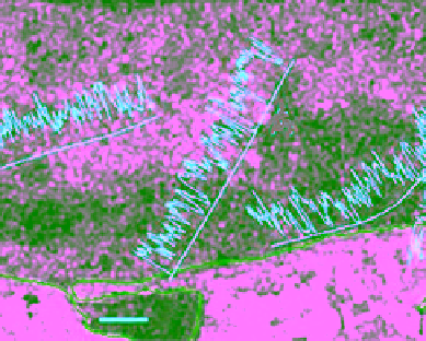
Figure 10.40
Radarsat‐1 image of the southern area of the Gulf of St. Lawrence acquired on 18 March 1999,
with (a) ice thickness profiles measured by the EM helicopter‐based ice probe overlaid. The longitude and latitude
coordinates are shown at the vertical and horizontal axes, respectively. (b) An enlarged scene off the Tracadie Bay,
Prince Edward Island, with superimposed ice thickness from the same probe. The width of this Radarsat segment
in (a) is 17 km [
Peterson et al.
, 2000].
A more recent helicopter‐borne EM induction sys-
tem was developed by the German Alfred Wegener
Institute for Polar and Marine Research (AWI) in 2001.
The instrument was designed to measure systematic ice
thickness in the polar regions. It operates at two fre-
quencies of 3.68 and 112 kHz, which provide the best
sensitivity to ice conductivity and therefore ice thick-
ness. A 20 m cable is used to tow the EM bird under the
helicopter.
Haas et al.
[2009] describe the instrument,
its operation, main noise sources, drift, and calibration.
The instrument was used during six summer and winter
measurement campaigns between 2004 and 2006. The
authors confirmed that accurate measurements of
thickness can be obtained over level ice. For better per-
formance of the instrument over deformed and porous
ice, they recommended using coincident measure-
ments of the underside topography of the ice. This can
be obtained by upward‐looking sonar systems onboard
submarines or by divers.
Haas et al.
[2010] present
measurements of ice thickness from 2400 km long pan‐
Arctic survey lines (eastern and western flight lines)
using an EM bird installed under a Balser BT‐67 fixed
wing aircraft. The measurements were conducted in
April 2009. Much longer survey lines can be achieved
using the airborne bird compared to a helicopter‐borne
one. The airborne bird was towed using an 80 m cable
that could be cradled under the fuselage during the
takeoff and landing of the aircraft. When the flight
altitude was 100 m the bird was only 20 m above the
surface. The study concluded that older sea ice in much
of the Arctic Ocean in 2009 was similar or slightly
thicker the ice in 2007.
10.5. Ice surface TemperaTure
Sea ice temperature is an important climatic parameter
[
Comiso et al.
, 2003]. It is also an indicator of ice
thickness when the ice is thin (less than, say, 15 cm) and
snow free. Ice surface temperature (IST) can be estimated
using TIR or passive microwave observations. These
two approaches are presented separately to show their
potentials and ranges of applicability.