Geology Reference
In-Depth Information
Atmospheric Administration (NOAA) satellite series are
around 0.630, 0.865, and 1.160
μ
m wavelength. The spa-
tial resolution of AVHRR is 1.1 km at nadir and degrades
toward the far range. The Moderate Resolution Imaging
Spectroradiometer (MODIS) has 19 VIS/NIR channels
with different spatial resolutions. The Visible Infrared
Imaging Radiometer Suite (VIIRS), NASA's next genera-
tion of VIS/NIR space instrument launched onboard the
National Polar‐orbiting Partnership (NPP) satellite,
records data at a set of discrete wavelengths ranging from
the ultraviolet (0.45
μ
m) to the NIR (12
μ
m). Although it
has radiometric channels similar to those of the AVHRR,
the data from the VIS/NIR bands of VIIRS are acquired
at a much finer resolution (0.375 or 0.750 km at nadir). In
general, the VIS/NIR data are useful for sea ice applica-
tions because of their high sensitivity to water‐ice bound-
aries and flooded water on an ice surface.
Thermal infrared sensors measure the heat radiation
from the surface; therefore, the best images are obtained
just before dawn when solar heating effects are at a mini-
mum. Emitted energy in this spectral region is absorbed
by clouds and fog. Therefore, it is useful to combine VIS
and TIR imagery data to identify clouds and remove their
influences. Microwave radiation is emitted by the Earth's
surface in very small amounts. Accordingly, the signal
should be integrated over a large footprint (spatial resolu-
tion of a few kilometers or tens of kilometers) in order to
increase the signal‐to‐noise ratio. Microwave signals trave-
ling in the atmosphere are not affected by clouds, although
the shorter wavelengths (<20 mm) can be absorbed by
raindrops in severe storms. Active microwave (radar)
sensors generate their own illumination, hence the obser-
vations are independent of solar radiation. They are not
affected also by the presence of clouds of precipitation.
For that reason, they are called all‐time, all‐weather
sensors. The spatial resolution from active microwave sen-
sors can be as fine as a few meters. For operational ice
monitoring, 100 m is a practically sufficient resolution.
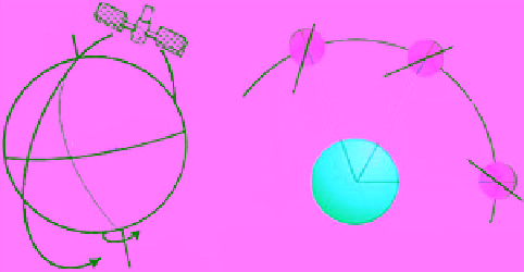
Based on the orbit type, EO satellites are grouped into
two categories: polar orbiting and geostationary. Polar
orbiting satellites allow global coverage. They orbit the
Earth at altitudes between 500 and 1400 km. The orbit is
typically inclined by 5° to 15° to the vertical (Figure 7.3a),
so they actually follow a near‐polar orbit. At altitudes
between 800 and 900 km, a satellite completes a full orbit
in about 100 min. During that time the Earth will rotate
around its polar axis, which is inclined by 25° to the vertical.
This leads to a shift of the ground track of the satellite
between successive orbits. Due to the curvature of the
Earth, a polar orbit satellite can cover the polar region
much more frequently than the equatorial. For example, a
satellite at 800 km orbit passes over the Arctic or the
Antarctic 11-12 times per day. That is enough to cover the
entire region if the swath of the satellite is wide enough
(a)
(b)
The orbit plane rotates at
the same rate of Earth's
rotation around the Sun
Near 90° orbit
Figure 7.3
Configuration of a satellite in (a) a near polar orbit
in (b) sun synchronous mode where the orbital plane must
rotate by approximately one degree per day eastward to keep
pace with the Earth's revolution around the Sun.
(e.g., around 2000 km). The repeat cycle of a polar orbit
satellite is defined as the number of days between two suc-
cessive identical orbits. It usually varies between 15 and
35 days depending on the altitude of the orbit.
The altitude and inclination of the orbit can be com-
bined to produce what is known as a Sun synchronous
orbit. In this trajectory, the angle between the Sun‐Earth
line and the plane of the satellite remains constant
throughout the complete rotation of the Earth around
the Sun (Figure 7.3b). This ensures that the satellite
ascends (heading north) or descends (heading south) over
any given point along the equator at the same mean solar
time. For example, a satellite might ascend across the
equator 12 times a day, each time at approximately
3:00 p.m. mean local time. This property is important in
the case of optical sensors because the surface illumina-
tion angle will be nearly the same every time the satellite
crosses a given latitude. In order to make the orbit of the
Canadian satellite Radarsat‐1 Sun synchronous, it is
placed at 798 km altitude but inclined by 98.4° to the
equator. With these parameters it crosses the equator at
6 p.m. and 6 a.m. in the ascending and descending modes,
respectively. It should be noted that at locations away
from the equator, particularly in the polar regions, the
local time of observation of a given swath can vary quite
considerably.
Geostationary satellites, on the other hand, follow a
circular orbit directly above the equator at an altitude of
35,786 km. The orbital speed at this altitude is 3.07 km/s,
which equals the linear speed of Earth's rotation.
Therefore, the satellite views the same part of Earth all
the time (uninterrupted). To an observer on the rotating
Earth the satellite appears stationary in the sky, hence the
name geostationary. The satellite usually covers one‐third
of Earth's surface. Therefore, the entire surface (except
the extreme polar regions) can be covered with three