Geology Reference
In-Depth Information
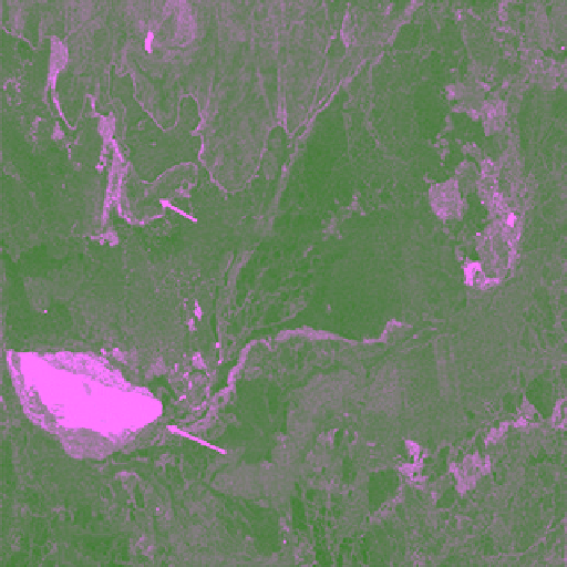
Cornwall Island
Belcher Island
2 km
Figure 5.52
Radarsat‐2 SAR image of an ice island in Belcher
Channel, near the south‐east corner of Cornwall Island, on 25
April 2010 in HH polarization; note the sandwiched structure
with the central bright and striped structure of Ward Hunt Shelf
Ice and MY sea ice rubble field on either side in HH view
(© MDA Geospatial Services).
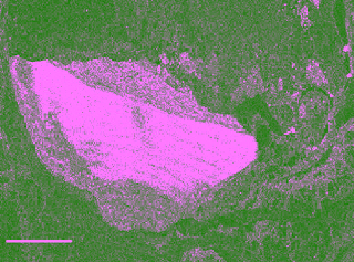
Ice Island
Belcher channel
Figure 5.51
Radarsat‐2 SAR image of an ice island in Belcher
Channel on 25 April 2010 in HH view (© MDA Geospatial
Services).
for the next generation of SAR with its fully polari-
metric feature are underway [including the launch of
the fully polarimetric Radarsat Constellation Mission
(RCM), scheduled for 2018], it is necessary to continue
with plans for comprehensive field programs (similar to
those initiated prior to the launch of Radatsa‐1) to
explore new applications. The fully polarimetric SAR
capability will allow retrieval of several parameters of
the ice surface and its snow cover that cannot be other-
wise retrieved using single‐ or dual‐channel SAR.
Particular attention should be given to young ice types,
although this is the most difficult type to examine in the
field. Full realization of the potential use of SAR pola-
rimetric data can only be achieved by linking the data to
coincident measurements of physical and geometrical
properties of ice and snow. That will allow development
of practical ranges of polarimetric parameters that may
prove to be useful in retrieving ice and snow parameters.
Otherwise the “guessing” of ice conditions under which
polarimetric data were acquired may not put radar
polarimtery to its full use for sea ice applications.
and haze. For several years, both Radarsat‐ 1 and 2
were functioning to provide complimentary images
Examples of Radarsat‐2 image of Ward Hunt Ice Shelf is
presented in Figure 5.50, and an image of an ice island
off Cornwall Island is shown in Figures 5.51 and 5.52.
The original resolution is 4.73 m (width) and 5.17 m
(length). The resolution and hence the quality of the
image is degraded to 9.46 m × 10.34 m in order to get the
size fit into this page. The approximate scale is included
in the image.
The legacy of Radarsat‐1 can be attributed to the
well‐planned early endeavor of assessing the merit of
the SAR data for sea ice applications. Launching field
measurement programs such as the multiyear multidis-
ciplinary experiment of Mould Bay (reported earlier in
in this chapter) was a rewarding endeavor as it contrib-
uted significantly to advance our understanding of the
physics of sea ice as a complex material and in relation
to its interaction with the microwave sensing. As plans