Geology Reference
In-Depth Information
The hazards of natural ice islands (tabular icebergs) in
the waters of the Arctic Ocean, the Beaufort Sea, and the
Northwest Passage were assessed extensively during the
late‐1980s to assist in the safe operation of ships and off-
shore structures (particularly offshore drilling platforms).
Research activities had focused on ice island numbers,
morphology, and remote sensing [
Jeffries et al.
, 1988;
Jeffries and Sackinger
, 1989], dynamics, motion, and
recurrence intervals [
Lu
, 1988], physical‐structural char-
acteristics and stratigraphy [
Jeffries et al.
, 1988], strength‐
related properties of shelf ice [
Frederking and Sinha
, 1987;
Frederking et al.
, 1988;
Jeffries and Sackinger
, 1990, 2012],
and medium‐scale, macroscale in situ strength and labora-
tory strengths of MY ridge ice [
Gagnon and Sinha
, 1991;
Meaney et al.
, 1992]
(a)
(b)
3.75m
3.83m
5.2.1. Background History of Ice Islands
When the leading edge of the East Ward Hunt Ice
Shelf in Ellesmere Island, west of the northern most sta-
tion Alert (Figure 5.35), broke away in 1982, Polar Shelf
decided to occupy the largest chunk of 45 m thick tabu-
lar body of ice measuring 8 km × 3 km, marked as No. 1,
in the airborne SAR image of Figure 5.36 and the aerial
photo in Figure 5.37. Recognizing its possibilities as
a moving research base, Polar Shelf actually erected a
base camp in 1984 and constructed several shelters to
accommodate research scientists. For almost 6 years,
from 1984 to 1990, PCSP base camp on ice island
was used for conducting multidisciplinary, wide‐ranging
geophysical research.
The tabular iceberg was nicknamed by the scientists
as the Hobson's Choice ice island. This name implies
the meaning “no choice.” However, there was another
deeper meaning for the name. It coincided with the con-
temporary Director of Polar Shelf, Mr. George Hobson
who played the pivotal role in the success story of Polar
Shelf and was much loved and respected by the scien-
tists, including the second author (N. K. Sinha) of this
topic. In fact, all of Sinha's efforts in training a group
of Inuit technical support persons at Pond Inlet, Baffin
Island, that led to pioneering field studies on sea ice in
Eclipse Sound [i.e.,
Sinha and Nakawo
, 1981;
Nakawo
and Sinha
, 1981] were supported financially and logisti-
cally by the Polar Shelf.
Following the separation from the East Ward Hunt ice
shelf in 1982, the ice island (Hobson's Choice) drifted
southwest in the Canada basin along the shores of the
islands for about 6 years as shown in Figure 5.35. This
drift pattern was expected to continue, but the floating
island stopped drifting after the winter of 1988-1989
and remained in the vicinity of the Meighen Ice Cap,
between Axel Heiberg Island and Ellef Ringnes Island,
until fragmented during the summer of 1990 when it
3.90m
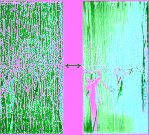
Figure 5.34
Views of (a) polarized scattered light and (b)
cross‐polarized light of interface at a depth of 3.83 m in a core
of ice from MY ice floe.
earlier in Figures 5.22-5.24. The same characteristics also
apply to the bottom layer of ice in the MY‐R floe (origi-
nally named as 4‐PEG floe) indicated in the sketch for
texture in Figure 5.33c. Note the columnar‐grained ice
below the depth of about 4.5 m. The top surface of this
MY‐R floe had undulations with rounded and, therefore,
weathered ridges and the top 4.5 m of the ice core
exhibited typical features of an MY rubble field. It is
not possible to determine the age of this old ridge, but
microstructural analysis (shown in the sketch) clearly
indicated that this ridged rubble field formed when the
original ice sheet was about 0.5 m thick.
5.2. thE icE island ExpEriEncE
Natural ice islands in the Arctic are the massive tabular
bodies of ice that periodically break off the East Ward
Hunt Ice Shelf located on the north coast of Ellesmere
Island in the Canadian High Arctic. Ice islands are recog-
nized as hazards to offshore petroleum development in
the coastal waters of the Beaufort and Chukchi Seas.
This is because of their size and their drift and longevity
in the Arctic Ocean Beaufort Gyre. However, smaller
“man‐made sea ice islands” were also made inside the
Canadian Archipelago during the years 1975-1985, by
artificially thickening the sea ice cover, for use as off-
shore drilling platforms for oil and gas exploration [
Sinha
et al
., 1986]. These man‐made ice islands, of course, never
survived more than 1 or 2 years of summer melting and
drifted within the islands of the archipelago.