Geology Reference
In-Depth Information
as huge blocks of ice and crush into the water. Greenland
glacier is the one that calves icebergs most frequently
in the Arctic. An estimated 12,000-15,000 icebergs are
calved annually. Icebergs may also originate from other
glaciers in the Arctic such as those in Ellesmere and
Devon Islands (Canada), Svalbard (Norway), and Novya
Zemlya (Russia). The Icebergs generated from Greenland
glacier are drifted southward by the ocean currents
through the Greenland Sea in the east and the Baffin Bay
in the west into the Atlantic Ocean. Eventually, the ice-
bergs and bergybits drifted in the Baffin Bay reach the
coast of Labrador and advance into the major shipping
lanes to the northeast of Newfoundland and the mouth
of the St. Lawrence River in Canada.
For many decades, since the tragic disaster of RMS
Titanic in 1912 that took the life of 1523 passengers and
crew when it collided with an iceberg not far from the
coast of Newfoundland, icebergs have been monitored in
the northern area of the Atlantic Ocean through special
programs operated by the Canadian Ice Service and the
International Ice Patrol. The former developed a pro-
gram to define the locations and the size of icebergs in the
Canadian east waters and predict their routes. The pro-
gram incorporates ship‐borne, airborne, and satellite‐
borne information. The airborne tolls used include
cameras, imaging radiometer, and most importantly
imaging radar. Numerous studies on the movements and
detection of icebergs have been carried out in Canada
and the United States, motivated by the Hibernia oil
exploration activities. Daily icebergs charts are issued to
define the location and size of icebergs in the East Coast
waters and forecast their positions at 00:00 UTC. While
icebergs do not exist in the Arctic Ocean (their presence is
limited to the sub‐Arctic seas and the north Atlantic),
they exist in the Southern Ocean. They may survive for
up to 10 years in this region. However, they are not con-
sidered as hazards to any particular navigational channel
simply because of the low traffic volume around the
Antarctic.
Ice Island is the other form of ice of land origin that
can be found floating within the sea ice cover. There is
a difference, however, between the origin of icebergs and
ice islands. Icebergs are calved from glaciers, while ice
islands are massive pieces that have broken away from
ice shelves. Their areas vary between a few thousand
square meters to a few hundred square kilometers. Their
thickness ranges between 30 and 50 m with about 5 m of
freeboard. It is important to note that Ice Island is an
Arctic term. In the Antarctic, any piece of ice, whether
calved‐off a glacier or broken off an ice shelf is called
iceberg. For example, the largest iceberg on record in the
Antarctic region, sighted in 1956 by the US Coast Guard
icebreaker USS Glacier, was tabular‐shaped with dimen-
sions 335 by 97 km. This is almost equal to the area of
Belgium and three times the area of Lebanon. Another
huge iceberg discovered using satellite images in 2000 was
calved from the Ross Ice Shelf with dimensions of 295 by
37 km. These icebergs can be as thick as the ice shelves
from which they calved.
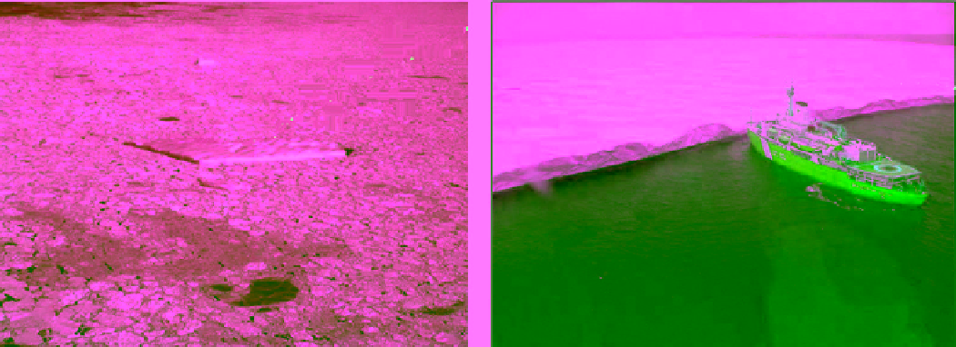
Ice Islands are characterized by their regularly undulat-
ing surface, giving a ribbed appearance from the air
(Figure 2.76). They are typically huge tabular ice masses,
(a)
(b)
Figure 2.76
Photographs of two pieces from what is believed to be the same ice island; (a) a fragment within a matrix of degraded
sea ice the Labrador Sea, photographed on April 19, 2002, and (b) a piece of 2.4 × 2.0 km
2
area and 9 m thick with the CCG
Icebreaker Louis St. Laurent, photographed on October 26, 2002 (photos courtesy of the Canadian Ice Service).