Geology Reference
In-Depth Information
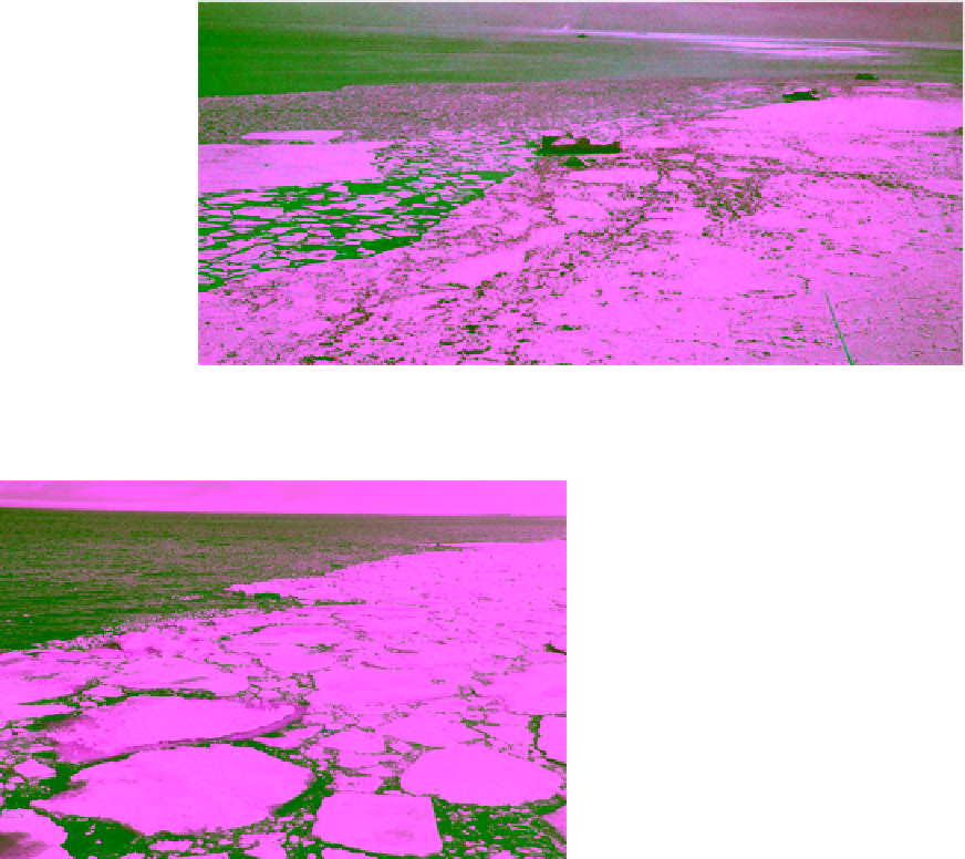
Figure 2.73
Transition between pack ice and open water in Smith Sound, north of Baffin Bay in June 1984. Three icebergs and
several bergybit appear along the depth of the scene (photographed by N. K. Sinha).
from a number of years, the minimum and maximum
extent of the edge, and the median position where the
frequency of occurrence of the edge is 50%. These
parameters vary with season as the pack ice expands and
retreats. The Canadian Ice Service generates regular
charts of monthly ice edges in certain operational areas
using airborne and ship observation. Snap shot of ice
edge at 1800 UTC on a specific day is also produced. The
accuracy of the charts is limited by the accuracy of the
data source, namely the positioning system on the vessel,
aircraft, or satellite platform. They may also be gener-
ated subjectively by ice analysts on ships. Ice edge charts
are used by coast guards to advise marine vessel opera-
tors on navigational routes. The US National Ice Center
also produces daily ice edge charts in certain areas.
Figure 2.74
Diffuse ice edge with high concentration of float-
ing floes (courtesy of the Danish Meteorological Institute).
2.6.5. Ice of Land Origin
ice sheet then splits it. This form is commonly observed
in fjords during spring and summer when fast ice is bro-
ken and the broken part is drifted. Another form of
compacted edge is caused by onshore wind which pushed
the ice floes against the shore on the windward side.
Diffuse ice edge, on the other hand, is weakly defined
compared to the clear‐cut definition of the compacted
edge. It refers to an area of dispersed ice which usually
occurs on the leeward side of drifted ice regime
(Figure 2.73). The diffuse edge is usually instigated by
offshore winds when blow off the pack ice toward the
open sea. Ice floes will then be dispersed into the open
sea at different speeds depending on their size, concen-
tration, surface roughness, and wind speed. In between
these two limits, the ice edge can appear with well identi-
fiable edge but with somehow scattered ice floes at the
ice side as shown in Figure 2.74.
Ice edge is characterized in terms of a few parameters.
They include the average position based on observations
Ice of land‐based origin exists in ocean as floating or
attached to land. Floating ice calves from glaciers. Glaciers
are huge masses of snow and ice, accumulated on flat land
or land with topographical features and usually move
slowly from higher to lower ground (their motion is called
ice rivers). They may originate from ice caps, which are
located at high elevation land and not generally connected
with the sea. The materials of glaciers and their spatial
distribution are highly variable because of the long his-
tory of snow deposition, compaction, and cycles of sur-
face melting and freezing. Formation of cracks and
crevices are common phenomena of glaciers, leading to
further fissures during the journey towards the sea bound
before reaching the calving stations. If afloat, glacier ice
continuously spread. Ice of land origin includes the fol-
lowing formations [
MANICE
, 2005]:
1. Ice shelf: a floating fresh‐water ice sheet attached to
the shore. The shelf has considerable height above sea