Geology Reference
In-Depth Information
where conditions are favorable for their formation. For
example, they are more visible in the Antarctic ice field
where severe wind and ocean waves usually prevail. They
are also found in the Arctic though not identified with any
specific locations.
A cyclical pancake ice regime in the east of the
Greenland Sea is known as Odden ice Tongue (Odden
means headland in the Norwegian language). Turbulent
water prevails in this region. This phenomenon is often
observed annually with exceptions of some years. It is
caused by diversion of cold polar seawater eastward
away from the dominant East‐Greenland Current in
the vicinity of 72-74°N.
Comiso et al
. [2001] studied the
interannual variability of the Odden ice from 1979 through
1998 in relation to the North Atlantic Oscillation.
One of the well‐known pancake ice regimes in the
Antarctic exist in the Weddle Sea.
Doble et al
. [2003] pro-
vided a first quantitative estimate on pancake ice growth
rate in the Weddle Sea. They presented photographs of six
different pieces of pancake classified according to a scheme
suggested in their study. Examples of the pancake classes
include classical pancake formed from a cyclic accretion of
frazil ice, pancake having a highly porous lower layer, and
pancake with low‐porosity bottom layer on top of which a
younger ice layer has been formed. In addition to the famil-
iar bottom accretion process, the study introduced the
mechanism of a top‐layer growth of pancake ice. It is sug-
gested that the top‐growth mechanisms dominates the
thickness‐increase “once the growing platform becomes
consolidated enough to support the overtopping process.”
It should be noted that pancake ice is too small and thin to
affect marine operations. Its significance, however, is pro-
nounced in the context of radar backscatter and therefore
interpretation of imaging radar data (section 7.6.2.1).
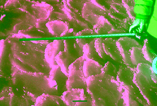
10 cm
Figure 2.71
Rafted pancake ice surface in the Labrador Sea in
March 1994. Ice was 0.38 m. The finger of the person in the
picture points to 0.78 m on the measuring tape (photographed
by M. Shokr).
edges (see section 2.6.4), pancake ice is more likely to
develop there. Pancake ice may also form by breaking
Nilas or even gray ice sheet under agitated conditions of
ocean gravity waves or swell. Both amplitude and wave-
length of the ocean waves contribute to the stresses
exerted on a thin ice sheet (e.g., Nilas). Waves that pene-
trate a thin ice sheet may exert forces large enough to
cause fractures of the sheet into pancake‐size pieces.
Long wavelengths do not break (or even bend) the ice as
quickly as short wavelengths. The exerted stress is mainly
a function of the rheological behavior of ice in addition
to the wave characteristics, including its travelling veloc-
ity. Waves with medium amplitude (≈1 m) or higher ampli-
tude will most likely break a sheet of grey ice (thickness
between 0.1 and 0.15 m) into pancake pieces. The break‐
up is enhanced by waves comprising multiple frequencies
superimposed on each other. At greater distances from
the ice edge into the pack ice, ocean waves subside and
pancakes start to freeze together and with frazil slush
between them to form a coherent ice floe or sheet. A cyclic
process termed the “pancake cycle” is described in
Wadhams et al
. [1987] and
Lange and Eicken
[1991].
If the pan cakes are formed in open water away from the
shore, they will be more or less round in shape. If they
form near a shoreline, they could possibility take an elon-
gated shape with the long axis parallel to the shore. In
both the cases, pancake ice field continues to grow in size
by rafting and interpancake bonding until vertical growth
dominates. At considerable distance from the ice edge
(>200 km), the ocean swell is damped. This allows a layer
of pancake ice to freeze and form what is known as con-
solidated pancake ice sheet. Sometimes, it forms at some
depth at an interface between water bodies of different
physical characteristics before floating to the surface.
Pancake ice regimes may be linked to geographic locations
2.6.4. Marginal Ice Zone and Ice Edge
Marginal ice zone (MIZ) is a climate‐related concept.
Ice edge, on the other hand, is a marine‐operational‐
related concept. Ice edge is a conventional boundary that
usually (but not always) falls within the MIZ. It is marked
by a threshold on ice concentration of 10 or 15%. It
should be noted that the same 15% ice concentration
threshold is used to define the ice extent (section 10.3).
Therefore, ice edge may coincide with the trace of the ice
extent. The first part of this section addresses the defini-
tion, significance and modelling of the MIZ. The second
part addresses briefly the issue of the ice edge.
2.6.4.1. Marginal Ice Zone
The marginal ice zone is a buffer between open water and
the pack ice. The latter refers to any area of floating ice that
has ice concentration >70% regardless of the ice form or
the way it is disposed. While there is no rigorous definition
of the MIZ, the definition given by
Wadhams et al
. [1986]