Geoscience Reference
In-Depth Information
1 Introduction
Several studies have shown considerable evidence that the Arctic sea ice is thinning
during the last decades (Haas et al.
2010
; Kwok et al.
2009
; Rothrock et al.
1999
).
When combined with the observed rapid reduction of the ice covered area (Comiso
2002
; Comiso et al.
2008
; Stroeve et al.
2012
) this leads to a decline in sea-ice
volume (Laxon et al.
2013
). The only remote sensing technique capable of quan-
tifying this ice-volume decrease at global scale is satellite altimetry. This method is
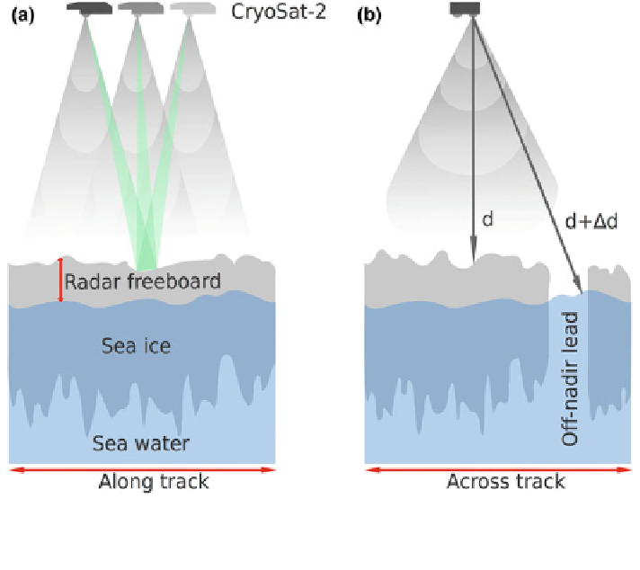
based on the retrieval of the sea-ice freeboard, which is the height of the ice-surface
above the local sea level (Fig.
1
a). Assuming hydrostatic equilibrium the freeboard
can be converted into sea-ice thickness (Giles et al.
2008
; Kwok et al.
2009
;
Wadhams et al.
1992
) and with additional information into sea-ice volume (Laxon
et al.
2013
).
Satellite altimeters are operated in different electromagnetic wavelength ranges.
The laser altimeter onboard the ICESat mission featured a small footprint (70 m)
but was affected by clouds. Radar altimeters on the other hand are not affected by
clouds but have a larger footprint of several kilometres. CryoSat-2 is the current
Fig. 1 a Scheme of CryoSat-2 measurements along track. The green illuminated area illustrates a
Doppler cell. b Scheme of CryoSat-2 measurement across track with an off-nadir lead at the edge
of the main radar lobe, causing a range bias of
d
D
Search WWH ::

Custom Search