Geology Reference
In-Depth Information
M
OUNT
C
REAN
(CRE)
100 KM
T
AYLOR
G
LACIER
(TYR)
I
NLAND
F
ORTS
(ILD)
M
OUNT
B
ALDR
(MBR)
M
C
M
URDO
S
TATION
M
C
K
AY
G
LACIER
(MCY)
A
LLAN
H
ILLS
F
AR
W
ESTERN
(ALH)
M
OUNT
D
EWITT
(DEW)
P
URGATORY
P
EAK
(PGP)
A
LLAN
H
ILLS
M
IDDLE
W
ESTERN
(ALH)
A
LLAN
H
ILLS
N
EAR
W
ESTERN
(ALH)
A
LLAN
HILLS
M
AIN
(ALH)
E
LEPHANT
M
ORAINE
(EET)
T
EXAS
B
OWL
/
M
ETEORITE
C
ITY
(EET)
O
DELL
G
LACIER
(ODE)
R
ECKLING
M
ORAINE
(RKP)
N
ORTHERN
I
CE
P
ATCH
(EET)
R
ECKLING
P
EAK
D
AVID
G
LACIER
(DAV)
B
ECKETT
N
UNATAK
(BEC)
O
UTPOST
N
UNATAK
(OTT)
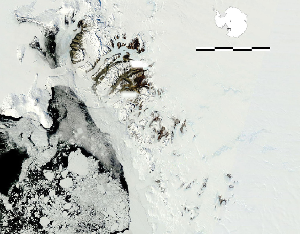
Figure 2.1(a through e).
Meteorite concentration localities explored by ANSMET to date. The localities shown represent tar-
gets of ANSMET field seasons, typically icefields or groups of icefields within a target region. All location names should be
considered informal, and where meteorites have been recovered the appropriate three-letter location code assigned to those
specimens (e.g., ALH) is shown. In many cases a single code is used for several icefields, particularly where smaller geographical
features were unnamed. The outline of Antarctica above the scale bar shows the approximate context of the figure within the
Transantarctic Mountains. For additional context, a few geographical features are also shown in blue. A mosaic of MODIS
Rapid Response Terra images (250-m resolution) is used as a base for all sections of the figure.
Figure 2.1a.
ANSMET meteorite localities in the McMurdo Sound region, including many of the sites explored in the earliest
period of ANSMET activity.
features of promising sites. Such flights were a common
feature of early ANSMET seasons and remain a part of
our reconnaissance tool kit, given their ability to reveal
current surface features and conditions (rather than those
in maps or images that can be decades old). On several
occasions, “low and slow” flights led to the identification
of meteorites from the air in areas where terrestrial rock
was known to be absent; but in general, such discoveries
have been very rare due to the small average size of mete-
orite specimens, the vibration of the aerial platform, and
the limits of human visual acuity.
Satellite imagery became publicly accessible at about
the same time ANSMET was formed, and with each
technological advance it has played an increasing role in
the project. ANSMET first used Landsat satellite imagery
for reconnaissance purposes in the late 1970s, with
significant help from the U.S. Geological Survey (USGS)
[e.g.,
Lucchitta et al.
, 1987]. Although initially restricted
to latitudes north of 80° S and with limited surface
resolution (80 m initially, 15 m later), the “bird's eye
view” and geolocation afforded by this imagery dramati-
cally improved ANSMET's identification of targets for