Geography Reference
In-Depth Information
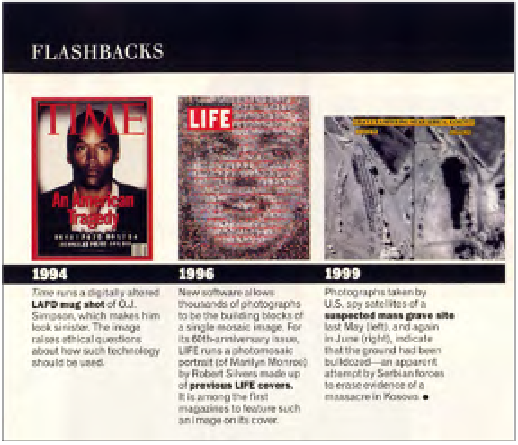
U.S.spysatelliteimageryfeaturedin
Life
magazine's“GreatPicturesoftheCentury
andtheStoriesBehindThem.”
LIFE MAGAZINE (OCTOBER 1999), P. 66
massacre and showing the grave. Then a second set was shown by the Pentagon
in June, showing that the grave had been destroyed—no doubt in response to the
first images. They were all, of course, part of a campaign to persuade the public
that the air war over Yugoslavia was just and necessary. When, at the end of the
year and the end of the century,
Life
magazine chose the “Great Pictures of the
Century,” the first Izbica image was featured as the single image from 1999 included
in the “Flashbacks” section.
33
I thought the story and especially the images were
worth pursuing.
Due to their classification (we still don't know which satellite took the picture),
NATO and the Department of Defense released the images simply as a series of
locked pixels with undetermined coordinates.
34
Where was the grave, precisely?
Investigating the archive of SPOT image data collected throughout the eleven-
week air war, I found only two cloudless days. This led me to guess that the mili -
tary had taken the famous images on one of those days. In tandem with another
image, taken by a German military drone and released by the Bundeswehr as part
of its own public-relations campaign, I was able to deduce the longitude and lati -
tude of the grave.
SPOT 083-264
insists on the necessity of linking satellite images to the data
that accompany their production, not simply for technical reasons, but for ethical
and political ones as well. Now, reinscribed with the data that created it, the image
becomes a memorial to an evacuated violence.
Search WWH ::

Custom Search