Graphics Reference
In-Depth Information
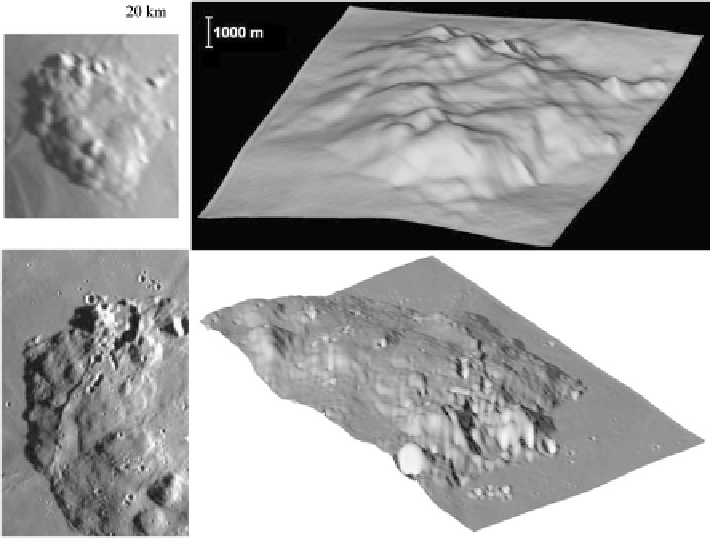
Fig. 8.29
(
a
) Telescopic CCD image of the dome complex Mons Rümker, situated in northwest-
ern Oceanus Procellarum. The individual edifices R1-R6 are indicated. The image is rectified to
perpendicular view, north is indicated by the
white arrow
. Image credit: K.C. Pau. (
b
) Perspective
view of the DEM of Mons Rümker obtained based on the image shown in (
a
) (from southeastern
direction). The vertical axis is 10 times exaggerated, the curvature of the lunar surface has been
subtracted. (
c
) Section from SMART-1 AMIE image LR3-R01914-00017-00100. The image reso-
lution corresponds to 218 m per pixel. Image credit: ESA/J.-L. Josset/B. Grieger. (
d
) Perspective
view of the DEM of Mons Rümker obtained based on the image shown in (
c
) (from northeastern
direction). The vertical axis is 10 times exaggerated, the curvature of the lunar surface has been
subtracted
stabilise the convergence behaviour and facilitate at the same time the reconstruc-
tion of small-scale surface features. The DEM shows that the height of the plateau
amounts to about 900 m in its western and northwestern part, 1100 m in its south-
ern part, and 650 m in its eastern and northeastern part. The overall volume of
erupted lava corresponds to about 1800 km
3
. About 30 individual domes on the
Rümker plateau are described by Smith (
1974
), six of which are sufficiently well re-
solved in the telescopic CCD image for morphometric evaluation. The DEM derived
for Mons Rümker is qualitatively consistent with the Apollo 15 orbital photograph
shown in Fig.
8.19
. Using a low-Sun image acquired by the AMIE camera on board
the SMART-1 spacecraft
8
(cf. Fig.
8.29
c), a more detailed DEM of Mons Rümker
8
The SMART-1 AMIE images are accessible at the ESA Planetary Science Archive at
http://www.


Search WWH ::

Custom Search