Geography Reference
In-Depth Information
Heilongjiang
Jilin
Inner Mongolia
Liaoning
Beijing
Tianjin
Hebei
Hebei
Shanxi
Ningxia
Shaanxi
Shandong
Gansu
Gansu
Qinghai
Henan
Jiangsu
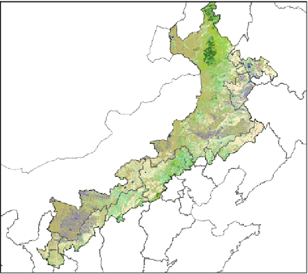
Fig. 3.13
The transformed land cover map over farming-pastoral ecotone in 2000
3.3.3 Results and Discussion
3.3.3.1 Evaluating the Accuracy of the Land Cover Classification
Using the method mentioned above, a Serving Climate Simulation Land Cover
(SCSLC) map is generated with a decision rule based on multi-source spatial data
mining in the farming-pastoral ecotone of North China (Fig.
3.13
). To analyze the
characteristics of this map, we compare the area of each land cover class in this map
with other three popular land cover maps, i.e., the WESTDC map, UMD map and
GLC map. The overall areas of each land cover class in the four maps were shown
according to the same classification (Table
3.10
). It is notable that the SCSLC map
using the C4.5 classifier is similar to the WESTDC map, but there is remarkable
increase in the cropland/natural vegetation mosaics and the corresponding decrease
in grassland. We also find that the accuracy of the GLC map and UMD map is lower
than that of the SCSLC and WESTDC. The GLC map ignores the urban and Built-up
land and the UMD ignores the Water Bodies in the farming-pastoral ecotone of North
China, but two kinds of land cover types are vital to the climate simulation.