Geography Reference
In-Depth Information
120°
E
120
°
E
121
°
E
km
N
0 25
50
12.5
32° N
32° N
31° N
31° N
119°E
120°E
121°E
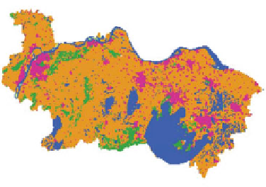
Cultivated land
Forestry
Grassland
Water area
Built-up area
Unused land
Fig. 6.5
Location of Southern Jiangsu
Land use data is mainly used for scenario-based simulations of land use change.
In this study, land use data of Southern Jiangsu province in 2000 and 2008 are
obtained through remote sensing images interpretation. These land use data are
composed of six land types, including farmland, forestry land, grassland, built-up
land, water bodies, and bare land. Among them, land use data in 2000 came from
the Land Use Database of Data Center Resources and Environment, Chinese
Academy of Science (Liu et al.
2002
). The database consists of interpretation
results from Landsat TM/ETM+ images with a spatial resolution of 30 9 30 m.
Land use data in 2008 is interpreted from Landsat ETM+ images by the authors.
Social and economic statistical data includes the population of Southern Jiangsu
province, per capita retail sales of social consumer goods, the total investment in
fixed assets, per capita fiscal revenue, the gross output of the second industry, and
grain yield per unit area from 2000 to 2008. The above data comes from Jiangsu
Statistical Yearbook.
Natural environmental indicators include DEM, the distance from the city at all
levels, the distance from the railways, the distance from the roads, and the distance
from the rivers. DEM data comes from Shuttle Radar Topography Mission
(SRTM) of NASA. This part hierarchically calculated the distance from the city at
all levels to each 100 9 100 m grid. Using the Landsat TM/ETM+ geometric
correction in 2000 that covered Southern Jiangsu province to outline the major
river systems and the network of transport of the study area and to work out the
distance from each 100 9 100 m grid to railways, roads and rivers.
6.2.1.2 DLS Model
DLS is a land use dynamic simulation model based on land use change mecha-
nism, DLS model consists of four modules, including scenario analysis module,