Geoscience Reference
In-Depth Information
no additional cells can be opened to urbanization. We may now either exclude
N
emp
-
N
norm
grid squares from further urbanization or accept urbanization, but, in that case,
applying the defined standard again for the following steps. It is obvious that for
shrinking cities, we can define which and how many grid squares can be reconverted
into green areas. However, if
N
emp
<
N
norm
an amount of
N
norm
-
N
emp
, grid squares
can be chosen for urbanization. In the next step, each of these grid squares is divided
into nine smaller squares, with sides one-third of the length of the size of the initial
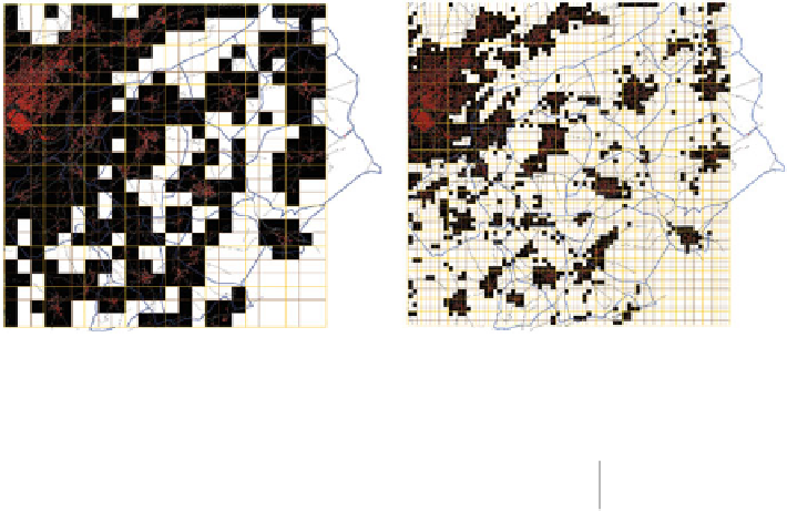
ones (Fig.
2.12
). In each of the grid squares retained for urbanization in the first step,
we look again among the nine smaller grid squares to see which of them contain
buildings. Of course, since our grid squares are smaller, we will again find empty
ones within the larger grid squares occupied at the previous step.
The grid squares excluded from urbanization at a certain step are never again
considered in further steps, so stringently respecting the lacunal hierarchy of
fractals. By choosing a standard
N
norm
, we define, of course, a fractal dimension
since the reduction factor is set at
r
D
1/3. Hence, the fractal dimension
D
norm
becomes a
multiscale land occupation index
and hence a planning standard. It
describes how the built-up area is concentrated in space across scales: if
D
tends
to two, the built-up mass is uniformly distributed, but the lower the value of
D,
the
more the built-up area is locally concentrated (Table
2.4
).
Fig. 2.12
Two successive steps of decomposition used for developing planning scenarios with
MUP-city (Source: Frankhauser et al.
2008
)
Tabl e 2. 4
The relation
between occupied grid
squares and fractal dimension
in MUP-city
Number
N
of occupied grid squares
at each scale
Fractal dimension
D
4
1.26
5
1.46
6
1.63
7
1.77


Search WWH ::

Custom Search