Geoscience Reference
In-Depth Information
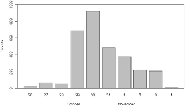
Fig. 14.12
Progression of tweets mentioning the word “flood” in the New York City area
overcome this limitation because of its high temporal resolution. For example, the
peak in the number of tweets containing the word “flood” occurs on October 29 and
30, 2012 immediately before and during landfall of Hurricane Sandy in New York
City the night of October 29th (Fig.
14.12
). Having an indication of event timing
can be a very effective aid for emergency managers and response initiatives.
14.3
Evacuations During Emergencies
Emergency evacuations during natural and anthropogenic disasters are time sen-
sitive and require detailed spatiotemporal information for emergency planners to
mitigate evacuee risk. One of the primary goals of emergency personnel is to
reduce the likelihood of injury and death for citizens within an evacuation zone.
First responders are entrusted with providing accurate evacuation information to the
public, especially to special populations (e.g., children, elderly, and disabled people
are at increased risk during evacuations). Fusing non-authoritative and authoritative
information provides increased situational awareness for crisis response personnel.
This information enables them to better understand where incidents are occurring,
how many people are at risk, and where to allocate resources. The ability to
minimize response time is critical to minimizing loss of life and limb.
This section discusses the importance and challenges of evacuations, mobile
phone data and its collection, issues of privacy with mobile phone data, and how
the use of mobile phone data in evacuations can enhance situational awareness of
emergency response planners.
Emergency response personnel can use non-authoritative data, such as near real-
time mobile location data, to increase their situational awareness and to redirect
resources as needed within their jurisdiction. Figure
14.13
shows a subset of
Search WWH ::

Custom Search